Capilla del Huizteco
Capilla del Huizteco is a church in Taxco de Alarcón, Guerrero. Capilla del Huizteco is situated nearby to the peak Cerro El Huixteco.| Tap on a place to explore it |
Places of Interest Nearby
Highlights include Santa Prisca Church.
Santa Prisca Church
Church
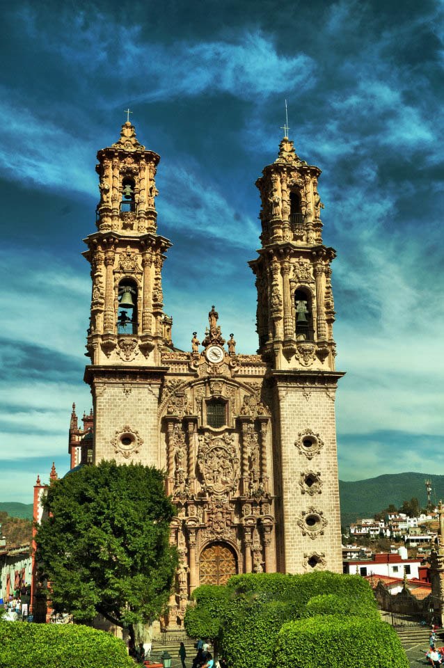
Photo: Mario guerrero ledesma 1, CC BY-SA 3.0.
The Parroquia de Santa Prisca y San Sebastían, commonly known as the Church of Santa Prisca, is a colonial monument located in the city of Taxco de Alarcón, in the southern state of Guerrero, Mexico, built between 1751 and 1759. Santa Prisca Church is situated 3½ km south of Capilla del Huizteco.
Places in the Area
Nearby places include Taxco and Tetipac Municipality.
Taxco

Photo: AlejandroLinaresGarcia, CC BY-SA 4.0.
Taxco is a beautiful city in Mexico built on a hill in Guerrero. It is rich with old and new silver mines in the surrounding areas with narrow winding streets and hundreds of silver shops.
Tetipac Municipality
Town
Tetipac is a municipality in the Mexican state of Guerrero. The municipal seat lies at Tetipac. The municipality covers an area of 269.3 km2. As of 2005, the municipality had a total population of 12,702. Tetipac Municipality is situated 8 km northwest of Capilla del Huizteco.
Capilla del Huizteco
- Type: Church
- Denomination: Catholic
- Categories: place of worship and religion
- Location: Taxco de Alarcón, Guerrero, Pacific Coast, Mexico, North America
- View on OpenStreetMap
Latitude
18.58734° or 18° 35′ 14″ northLongitude
-99.61255° or 99° 36′ 45″ westOpen location code
76C2H9PP+WXOpenStreetMap ID
node 7103172390OpenStreetMap feature
amenity=place_of_worshipOpenStreetMap attribute
denomination=catholic
This page is based on OpenStreetMap, Wikidata, and Wikimedia Commons.
We’d love your help improving our open data sources. Thank you for contributing.
Satellite Map
Discover Capilla del Huizteco from above in high-definition satellite imagery.
Notable Places Nearby
Highlights include Cerro El Huixteco and Parque Recreativo El Huixteco.
Nearby Places
Explore places such as Teleférico Taxco and Los Arcos.
Guerrero: Must-Visit Destinations
Delve into Acapulco, Chilpancingo, Taxco, and Iguala.
Curious Churches to Discover
Uncover intriguing churches from every corner of the globe.
About Mapcarta. Data © OpenStreetMap contributors and available under the Open Database License". Text is available under the CC BY-SA 4.0 license, except for photos, directions, and the map. Photo: Wikimedia, CC0.