City of Rochester Police Department
City of Rochester Police Department is a police station in Rochester, Rochester and Suburbs, New York which is located on Jay Street. City of Rochester Police Department is situated nearby to Lyell Branch Library, as well as near the hamlet Gates Center.| Tap on a place to explore it |
Places of Interest Nearby
Highlights include Blue Cross Arena and Susan B. Anthony House.
Blue Cross Arena
Stadium
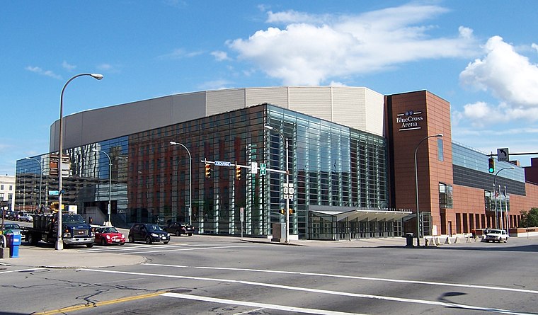
Photo: LtPowers, CC BY-SA 3.0.
Blue Cross Arena, also known as the War Memorial, is a multi-purpose indoor arena located in Rochester, New York. For hockey and lacrosse, its seating capacity is 10,662. Blue Cross Arena is situated 2 miles east of City of Rochester Police Department.
Susan B. Anthony House
Museum

Photo: Wikimedia, Public domain.
Susan B. Anthony House, in Rochester, New York, was the home of Susan B. Anthony for forty years, while she was a national figure in the women's rights movement. Susan B. Anthony House is situated 1¼ miles east of City of Rochester Police Department.
Innovative Field
Stadium

Photo: TwinsMetsFan, CC BY-SA 3.0.
Innovative Field is a baseball stadium at One Morrie Silver Way in downtown Rochester, New York. It has been the home of the Rochester Red Wings of the International League since 1997. Innovative Field is situated 1½ miles east of City of Rochester Police Department.
Places in the Area
Nearby places include Gates Center and South Wedge Historic District.
Gates Center
Hamlet
Gates Center is a hamlet within the town of Gates in Monroe County, New York, United States. It occupies the southern part of the census-designated place of Gates. The hamlet of Gates Center is served by Gates-Chili Central School District. Gates Center is situated 2 miles west of City of Rochester Police Department.
South Wedge Historic District
Neighborhood
Photo: KLOTZ, CC BY-SA 4.0.
South Wedge is a historic district and neighborhood in southeast Rochester, New York, in a predominantly residential section of the city. The district includes a variety of buildings constructed between the 1840s and 1920s, mainly two-story detached family residences. South Wedge Historic District is situated 2½ miles southeast of City of Rochester Police Department.
Maplewood Historic District
Neighborhood
The Maplewood Historic District is located in Rochester in Monroe County, New York. The district is distinguished as having landscape designs, including Maplewood Park, originally laid out by Frederick Law Olmsted. Maplewood Historic District is situated 2½ miles north of City of Rochester Police Department.
City of Rochester Police Department
- Type: Police station
- Address: 1099 Jay Street, Rochester, NY 14611
- Location: Rochester, Rochester and Suburbs, Finger Lakes, New York, Mid-Atlantic, United States, North America
- View on OpenStreetMap
Latitude
43.15813° or 43° 9′ 29″ northLongitude
-77.65135° or 77° 39′ 5″ westOperator
City of Rochester Police DepartmentOpen location code
87M4585X+7FOpenStreetMap ID
node 7118391284OpenStreetMap feature
amenity=police
This page is based on OpenStreetMap, Wikidata, and Wikimedia Commons.
We’d love your help improving our open data sources. Thank you for contributing.
Satellite Map
Discover City of Rochester Police Department from above in high-definition satellite imagery.
Places with the Same Name
Discover other places named “City of Rochester Police Department”.
Notable Places Nearby
Highlights include Lyell Branch Library and RFD Truck 5.
Nearby Places
Explore places such as Water Tower Park and Station 18.
Rochester and Suburbs: Must-Visit Destinations
Delve into Fairport, East Rochester, Victor, and Spencerport.
Curious Police Stations to Discover
Uncover intriguing police stations from every corner of the globe.
About Mapcarta. Data © OpenStreetMap contributors and available under the Open Database License". Text is available under the CC BY-SA 4.0 license, except for photos, directions, and the map. Photo: LtPowers, CC BY-SA 3.0.