Kulmbacher Tafel e.V.
Kulmbacher Tafel e.V. is a social service facility in Kulmbach, Upper Franconia, Bavaria which is located on Blaicher Straße. Kulmbacher Tafel e.V. is situated nearby to the building Villa, as well as near the church Evangelische.| Tap on a place to explore it |
- Opening hours: Tuesday and Friday 10:00 AM—noon
- Email: elfriede.hoehn@gmx.de
- Type: Social service facility
- Address: Blaicher Straße 20, Kulmbach, 95326
Places of Interest Nearby
Highlights include Evangelische and Plassenburg.
Evangelische
Church

Photo: Benreis, CC BY-SA 3.0.
Evangelische is a church, which is situated 250 metres northwest of Kulmbacher Tafel e.V..
Plassenburg
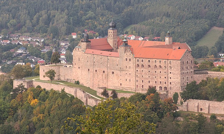
Photo: El Grafo, CC BY-SA 4.0.
Plassenburg is a castle in the city of Kulmbach in Bavaria. It is one of the most impressive castles in Germany and a symbol of the city. It was first mentioned in 1135. Plassenburg is situated 1 km south of Kulmbacher Tafel e.V..
Rathaus
Town hall

Photo: Tilman2007, CC BY-SA 3.0.
Rathaus is a town hall, which is situated 1 km south of Kulmbacher Tafel e.V..
Places in the Area
Nearby places include Ziegelhütten (Kulmbach) and Petzmannsberg.


Mangersreuth
Village
 Mangersreuth is a village, which is situated 3 km south of Kulmbacher Tafel e.V..
Kulmbacher Tafel e.V.
- Location: Kulmbach, Kulmbach, Upper Franconia, Franconia, Bavaria, Germany, Central Europe, Europe
- View on OpenStreetMap
Latitude
50.11628° or 50° 6′ 59″ northLongitude
11.46322° or 11° 27′ 48″ eastOpen location code
9F2H4F87+G7OpenStreetMap ID
node 7148953458OpenStreetMap feature
amenity=social_facility
This page is based on OpenStreetMap, Wikidata, and Wikimedia Commons.
We’d love your help improving our open data sources. Thank you for contributing.
Satellite Map
Discover Kulmbacher Tafel e.V. from above in high-definition satellite imagery.
Notable Places Nearby
Highlights include Villa and Klinikum Kulmbach.
Nearby Places
Explore places such as SINTENIS dekorieren & schenken and Kulmbach, H.-Limmer-Str..
Upper Franconia: Must-Visit Destinations
Delve into Bamberg, Bayreuth, Coburg, and Hof.
Curious Social Service Facilities to Discover
Uncover intriguing social service facilities from every corner of the globe.
About Mapcarta. Data © OpenStreetMap contributors and available under the Open Database License". Text is available under the CC BY-SA 4.0 license, except for photos, directions, and the map. Photo: Wikimedia, CC0.