Hängertzaun
Hängertzaun is a dwelling in Lauterbrunnen, Interlaken-Oberhasli, Canton of Bern. Hängertzaun is situated nearby to the waterfall Sefinenfall, as well as near the power station Kraftwerk Stechelberg.| Tap on a place to explore it |
Places of Interest Nearby
Highlights include Trümmelbach Falls and Schwarzmönch.
Trümmelbach Falls
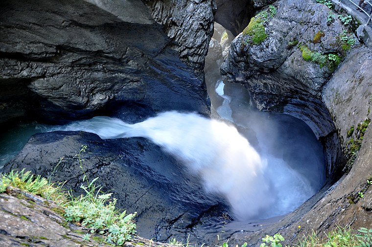
Photo: Simisa, CC BY-SA 3.0.
The Trümmelbach Falls in Bernese Oberland, Switzerland, are a series of ten glacier-fed waterfalls inside the mountain made accessible by the tunnel lift, stairs, and illumination. Trümmelbach Falls is situated 3 km northeast of Hängertzaun.
Schwarzmönch
Peak

Photo: Simisa, CC BY-SA 3.0.
The Schwarzmönch is a mountain of the Bernese Alps, overlooking Lauterbrunnen in the Bernese Oberland. It forms a huge buttress on the north-west side of the Jungfrau, to which it is connected by the ridge named Ufem Schwarzen Grat. Schwarzmönch is situated 2½ km east of Hängertzaun.
Bietenhorn
Peak

Photo: Sandstein, CC BY-SA 3.0.
The Bietenhorn is a mountain of the Bernese Alps, located north of Mürren in the Bernese Oberland. It lies north-east of the Schilthorn, on the range between the Soustal and the main Lauterbrunnen valley. Bietenhorn is situated 4 km northwest of Hängertzaun.
Places in the Area
Nearby places include Gimmelwald and Stechelberg.
Gimmelwald

Photo: Chensiyuan, CC BY-SA 4.0.
Gimmelwald is a picturesque hamlet in the Bernese Oberland of Switzerland. It's perched on a cliff edge looking down into the Weisse Lütschine valley towards Lauterbrunnen, and in 2020 had a population of 130.
Stechelberg
Village

Photo: Thisisbossi, CC BY-SA 2.5.
Stechelberg is a small village in Switzerland located at the base of the Schwarzmönch mountain in the Bernese Alps, part of the district of Lauterbrunnen.
Mürren

Photo: Thisisbossi, CC BY-SA 2.5.
Mürren is a mountain village in the Bernese Oberland of Switzerland, with a resident population of 155 but hundreds of seasonal workers and 2000 hotel guests.
Hängertzaun
- Type: Dwelling
- Categories: locality, residential building, and building
- Location: Lauterbrunnen, Interlaken-Oberhasli, Canton of Bern, Bernese Highlands, Switzerland, Central Europe, Europe
- View on OpenStreetMap
Latitude
46.54648° or 46° 32′ 47″ northLongitude
7.88987° or 7° 53′ 24″ eastOpen location code
8FR9GVWQ+HWOpenStreetMap ID
node 7164825198OpenStreetMap feature
place=isolated_dwelling
This page is based on OpenStreetMap, Wikidata, and Wikimedia Commons.
We’d love your help improving our open data sources. Thank you for contributing.
Satellite Map
Discover Hängertzaun from above in high-definition satellite imagery.
Notable Places Nearby
Highlights include Sefinenfall and Kraftwerk Stechelberg.
Nearby Places
Explore places such as Bischoffsmatte and Gimmelwald.
Bernese Highlands: Must-Visit Destinations
Delve into Thun, Interlaken, Grindelwald, and Meiringen.
Curious Dwellings to Discover
Uncover intriguing dwellings from every corner of the globe.
About Mapcarta. Data © OpenStreetMap contributors and available under the Open Database License". Text is available under the CC BY-SA 4.0 license, except for photos, directions, and the map. Photo: Edwin Lee, CC BY 2.0.