Laufstrecken Innerste Aue
Laufstrecken Innerste Aue is in Hildesheim, Hanover Region, Lower Saxony. Laufstrecken Innerste Aue is situated nearby to the sports venue GR Eintracht Hildesheim, Tennishalle, as well as near the playground JoWiese.| Tap on a place to explore it |
Places of Interest Nearby
Highlights include St. Godehard and St. Michael’s Church.
St. Godehard
Church

Photo: Hoger, CC BY-SA 3.0 de.
St. Godehard is a church in Hildesheim, Germany, formerly the church of a Benedictine abbey. It remained almost unaltered through the centuries and was not damaged much in World War II. St. Godehard is situated 440 metres northeast of Laufstrecken Innerste Aue.
St. Michael’s Church
Church
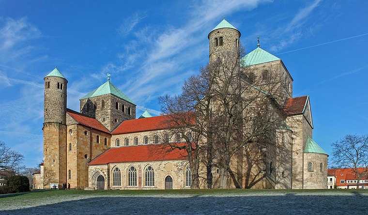
Photo: Heinz-Josef Lücking, CC BY-SA 3.0 de.
The Church of St. Michael is an early-Romanesque church located in Hildesheim, Germany. It has been on the UNESCO World Cultural Heritage list since 1985 due to the before mentioned early-Romanesque architecture and art found within such as the Tree of Jesse and the now relocated Bernward Doors. St. Michael’s Church is situated 1 km north of Laufstrecken Innerste Aue.
Ernst-Ehrlicher-Park
Protected area

Photo: Ragnar1904, CC BY-SA 4.0.
Ernst-Ehrlicher-Park is a protected area, which is situated 340 metres east of Laufstrecken Innerste Aue.
Places in the Area
Nearby places include Moritzberg and Barienrode.
Moritzberg
Neighborhood
Moritzberg is a quarter in the city of Hildesheim in Lower Saxony, Germany. It is on a hill in the west of the city, about a mile from the Cathedral. It was an independent market town until 1911.
Barienrode
Village

Photo: Torbenbrinker, CC BY-SA 3.0.
Barienrode is a village, which is situated 3½ km south of Laufstrecken Innerste Aue.
Sorsum
Suburb
Sorsum, a district of the city of Hildesheim, is a small village in northern Germany. Sorsum is situated 4½ km west of Laufstrecken Innerste Aue.
Laufstrecken Innerste Aue
- Type: Map
- Categories: information and tourism
- Location: Hildesheim, Hildesheim, Hanover Region, Lower Saxony, Germany, Central Europe, Europe
- View on OpenStreetMap
Latitude
52.14283° or 52° 8′ 34″ northLongitude
9.94497° or 9° 56′ 42″ eastOpen location code
9F4F4WVV+4XOpenStreetMap ID
node 7217001809OpenStreetMap feature
tourism=information
This page is based on OpenStreetMap, Wikidata, and Wikimedia Commons.
We’d love your help improving our open data sources. Thank you for contributing.
Satellite Map
Discover Laufstrecken Innerste Aue from above in high-definition satellite imagery.
Notable Places Nearby
Highlights include GR Eintracht Hildesheim, Tennishalle and JoWiese.
Nearby Places
Explore places such as 🚲 Wege und Ziele in Hildesheim and Kulturroute.
Hanover Region: Must-Visit Destinations
Delve into Hanover, Nienburg, Verden an der Aller, and Alfeld.
Curious Places to Discover
Uncover intriguing places from every corner of the globe.
About Mapcarta. Data © OpenStreetMap contributors and available under the Open Database License". Text is available under the CC BY-SA 4.0 license, except for photos, directions, and the map. Photo: Mey2008, CC BY-SA 3.0.