Punta di Bonifacio
Punta di Bonifacio is a peak in Zonza, Arrondissement of Sartène, Corsica and has an elevation of 1,276 metres. Punta di Bonifacio is situated nearby to the locality Pineto Piano, as well as near Crêtes des Terrasses.| Tap on a place to explore it |
Places of Interest
Highlights include Col de Bavella.
Places in the Area
Nearby places include Aiguilles de Bavella.
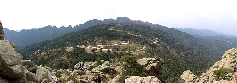
Aiguilles de Bavella
Locality

Photo: Wikimedia, CC BY-SA 3.0.
The Aiguilles de Bavella are rocky spikes of red granite that dominate the hill of the same name on the island of Corsica in France. At 1218 m, the hill connects the Alta Rocca to the east coast of Corsica.
Punta di Bonifacio
- Type: Peak with an elevation of 1,276 metres
- Also known as: “Pointe de Bonifacio”
- Category: landform
- Location: Zonza, Arrondissement of Sartène, South Corsica, Corsica, France, Europe
- View on OpenStreetMap
Latitude
41.7667° or 41° 46′ 0″ northLongitude
9.2472° or 9° 14′ 50″ eastElevation
1,276 metres (4,186 feet)Open location code
8FHFQ68W+MVOpenStreetMap ID
node 7242795345OpenStreetMap feature
natural=peak
This page is based on OpenStreetMap, Wikidata, and Wikimedia Commons.
We’d love your help improving our open data sources. Thank you for contributing.
Satellite Map
Discover Punta di Bonifacio from above in high-definition satellite imagery.
Localities in the Area
Explore places such as Pineto Piano and Crêtes des Terrasses.
Notable Places Nearby
Highlights include Bocca di Lariciu and Punta di u Larcietu.
Corsica: Must-Visit Destinations
Delve into Ajaccio, Bastia, Bonifacio, and Calvi.
Curious Peaks to Discover
Uncover intriguing peaks from every corner of the globe.
About Mapcarta. Data © OpenStreetMap contributors and available under the Open Database License". Text is available under the CC BY-SA 4.0 license, except for photos, directions, and the map. Photo: Pierre Bona, CC BY-SA 3.0.