Saint’s Bourbon Street
Saint’s Bourbon Street is a liquor store in Washington, D.C., Mid-Atlantic which is located on Hamlin Street Northeast. Saint’s Bourbon Street is situated nearby to Pleasant Grove Baptist Church, as well as near District of Columbia Public Library-Woodridge Neighborhood Branch.| Tap on a place to explore it |
Places of Interest Nearby
Highlights include District of Columbia Public Library-Woodridge Neighborhood Branch and Ralph Bunche House.
District of Columbia Public Library-Woodridge Neighborhood Branch
Library

Photo: Bookworm-ce, CC BY-SA 4.0.
The Woodridge Neighborhood Library is a branch of the District of Columbia Public Library in the Woodridge neighborhood of Washington, D.C. It is located at 1801 Hamlin Street NE. District of Columbia Public Library-Woodridge Neighborhood Branch is situated 370 feet south of Saint’s Bourbon Street.
Ralph Bunche House
House

Photo: Smallbones, CC0.
Ralph Bunche House was the home Ralph Bunche commissioned from Hilyard Robinson in 1941. It is located at 1510 Jackson Street, Northeast, Washington, D.C., United States, in the Brookland neighborhood. Ralph Bunche House is situated 1,600 feet northwest of Saint’s Bourbon Street.
Dance Place
Theater building

Photo: Erinandmally, CC BY-SA 4.0.
Dance Place is an arts organization in the Edgewood neighborhood of Northeast Washington, D.C. The nearest metro station is Brookland/CUA on the Red Line. Dance Place is situated 1 mile west of Saint’s Bourbon Street.
Places in the Area
Nearby places include Brookland and Langdon.
Brookland
Suburb
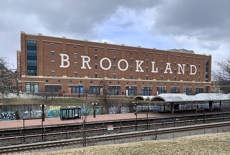
Photo: APK, CC BY-SA 4.0.
Brookland, Petworth, and Takoma are three relatively quiet neighborhoods east of Rock Creek Park. Following the "White Flight" after desegregation and the 1968 riots, these neighborhoods were left underpopulated, overwhelmingly African-American, and much less wealthy than the Upper Northwest, just across Rock Creek Park.
Langdon
Neighborhood
 Langdon, is a neighborhood located in Ward 5 of Northeast Washington, D.C. Historical surveys of D.C. recognize Langdon as a neighborhood dating back to at least 1903.
Brentwood
Neighborhood
 Brentwood is a neighborhood in Northeast Washington, D.C., Bounded by Rhode Island Avenue NE, the train tracks of the Rhode Island Ave-Brentwood Metro station, Montana Avenue NE, and New York Avenue NE.
Saint’s Bourbon Street
- Type: Liquor store
- Address: 1812 Hamlin Street Northeast
- Category: shop
- Location: Washington, D.C., Mid-Atlantic, United States, North America
- View on OpenStreetMap
Latitude
38.92842° or 38° 55′ 42″ northLongitude
-76.9784° or 76° 58′ 42″ westOpen location code
87C5W2HC+9JOpenStreetMap ID
node 737145436OpenStreetMap feature
shop=alcohol
This page is based on OpenStreetMap, Wikidata, and Wikimedia Commons.
We’d love your help improving our open data sources. Thank you for contributing.
Satellite Map
Discover Saint’s Bourbon Street from above in high-definition satellite imagery.
Notable Places Nearby
Highlights include Pleasant Grove Baptist Church and Washington District of Columbia Police Department - Youth Investigations and Family Violence.
Nearby Places
Explore places such as Rhode Island Liquor and Gearin‘ Up Bicycles.
Washington, D.C.: Must-Visit Destinations
Delve into West End, Georgetown, East End, and Shaw.
Curious Liquor Stores to Discover
Uncover intriguing liquor stores from every corner of the globe.
About Mapcarta. Data © OpenStreetMap contributors and available under the Open Database License". Text is available under the CC BY-SA 4.0 license, except for photos, directions, and the map. Photo: Peterfitzgerald, CC BY-SA 3.0.