Hummelsberg (Kernberge)
Hummelsberg (Kernberge) is a peak in Jena, Thuringia. Hummelsberg (Kernberge) is situated nearby to the locality Ziegenberg, as well as near Ernst-Haeckel-Höhe.| Tap on a place to explore it |
- Type: Peak
- Description: peak in the Jenaer Scholle, Thuringia, Germany
- Also known as: “Hummelsberg”
Places of Interest
Highlights include Zeiss-Planetarium Jena and Jena Phyletisches Museum.
Zeiss-Planetarium Jena
Planetarium
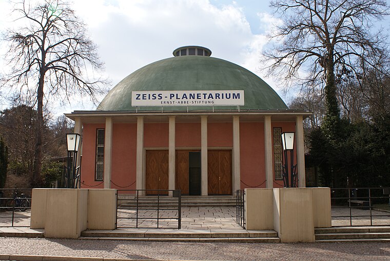
Photo: Selby, CC BY-SA 3.0.
The Zeiss-Planetarium in Jena, Germany, is the oldest continuously operating planetarium in the world. Engineered by German engineer Walther Bauersfeld, the building was opened on 18 July 1926.
Jena Phyletisches Museum
Museum

Photo: Gunnar brehm, CC BY-SA 3.0.
Jena Phyletisches Museum is a museum in the German town of Jena. It was established by the scientist Ernst Haeckel, as an institute dedicated to explaining evolution to the public.
Botanical Garden
Garden

Photo: Aka, CC BY-SA 2.5.
The Botanischer Garten Jena is the second oldest botanical garden in Germany, maintained by the University of Jena and located at Fürstengraben 26, Jena, Thuringia, Germany.
Places in the Area
Nearby places include Neulobeda and Lobeda.
Neulobeda
Suburb
Photo: Hamster3, CC BY-SA 2.5.
Neulobeda is the largest district of the Thuringian university town Jena with over 22,000 residents. The residents are distributed over an area of 3.6 km2.
Lobeda
Suburb
Photo: Oglobeda, Public domain.
Lobeda is a former independent city in Thuringia, Germany, which is now a district of Jena known as Lobeda-Old Town. It was incorporated in 1946, has just under 2000 inhabitants on an area of 3.36 square kilometers and is located just under 4.5 kilometers south of the city center.
Hummelsberg (Kernberge)
- Categories: hill and landform
- Location: Jena, Thuringia, Germany, Central Europe, Europe
- View on OpenStreetMap
Latitude
50.913° or 50° 54′ 47″ northLongitude
11.604° or 11° 36′ 14″ eastOpen location code
9F2HWJ73+6HOpenStreetMap ID
node 749244325OpenStreetMap feature
natural=peakWikidata ID
Q89187942
This page is based on OpenStreetMap, Wikidata, and Wikimedia Commons.
We’d love your help improving our open data sources. Thank you for contributing.
Satellite Map
Discover Hummelsberg (Kernberge) from above in high-definition satellite imagery.
In Other Languages
“Hummelsberg (Kernberge)” goes by many names.
- German: “Hummelsberg (Kernberge)”
Localities in the Area
Explore places such as Ziegenberg and Ernst-Haeckel-Höhe.
Notable Places Nearby
Highlights include ehem. B-Stelle FLAK and Ernst-Haekel-Bank.
Thuringia: Must-Visit Destinations
Delve into Erfurt, Weimar, Gera, and Eisenach.
Curious Peaks to Discover
Uncover intriguing peaks from every corner of the globe.
About Mapcarta. Data © OpenStreetMap contributors and available under the Open Database License". Text is available under the CC BY-SA 4.0 license, except for photos, directions, and the map. Photo: Taxiarchos228, FAL.