청우인터네셔널
청우인터네셔널 is in Sindang-dong, Jung, Seoul, Gyeonggi. 청우인터네셔널 is situated nearby to Seoul Jungbu Fire Station, as well as near the police station Yulwon Community Policing Center.| Tap on a place to explore it |
Places of Interest Nearby
Highlights include Seoul Jungbu Fire Station and Sindang.

Sindang
Metro station

Photo: LERK, CC BY-SA 4.0.
Sindang Station is a subway station on the Seoul Subway Line 2 and Line 6. The Line 2 station is located in Sindang-dong, and the Line 6 station in Heungin-dong, both within Jung-gu of Seoul. Sindang is situated 180 metres northeast of 청우인터네셔널.
Dongdaemun
City gate
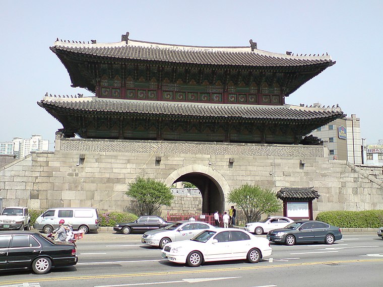
Photo: Karl Baron, CC BY-SA 2.0.
Heunginjimun, a.k.a. Dongdaemun, is one of The Eight Gates of Seoul in the Seoul City Wall, a prominent landmark in central Seoul, South Korea. The Korean name "Dongdaemun" means "Great East Gate," and it was so named because it was the major eastern gate in the wall that surrounded Seoul during the Joseon period. Dongdaemun is situated 1 km northwest of 청우인터네셔널.
Places in the Area
Nearby places include Hwanghak-dong and Bangsan-dong.

Bangsan-dong
Quarter
Bangsan-dong is a legal dong, or neighborhood, of Jung District, Seoul, South Korea and governed by its administrative dong, Euljiro 3, 4, 5ga-dong.
청우인터네셔널
- Type: Information
- Category: tourism
- Location: Sindang-dong, Jung, Seoul, Gyeonggi, South Korea, East Asia, Asia
- View on OpenStreetMap
Latitude
37.56443° or 37° 33′ 52″ northLongitude
127.01462° or 127° 0′ 53″ eastOpen location code
8Q99H277+QROpenStreetMap ID
node 7557537320OpenStreetMap feature
tourism=information
This page is based on OpenStreetMap, Wikidata, and Wikimedia Commons.
We’d love your help improving our open data sources. Thank you for contributing.
Satellite Map
Discover 청우인터네셔널 from above in high-definition satellite imagery.
Notable Places Nearby
Highlights include Yulwon Community Policing Center and 신당동 떡볶이공원.
Nearby Places
Explore places such as 썬마트 and 우주부동산.
Seoul: Must-Visit Destinations
Delve into Jongno, Incheon International Airport, Gangnam-Seocho, and South Seoul.
Curious Places to Discover
Uncover intriguing places from every corner of the globe.
About Mapcarta. Data © OpenStreetMap contributors and available under the Open Database License". Text is available under the CC BY-SA 4.0 license, except for photos, directions, and the map. Photo: Wikimedia, CC BY-SA 3.0.