29
29 is a scenic viewpoint in Jefferson, Kentucky. 29 is situated nearby to the scenic viewpoint 24, as well as near 30.| Tap on a place to explore it |
Places of Interest Nearby
Highlights include Central State Hospital and Kentucky Truck Assembly.
Central State Hospital
Hospital
Central State Hospital is a 192-bed adult psychiatric hospital located in the Lakeland neighborhood of Louisville, Kentucky. Central State Hospital is situated 1 mile southwest of 29.
Kentucky Truck Assembly
Factory
Kentucky Truck Plant is an automobile manufacturing plant owned by Ford Motor Company in Louisville, Kentucky. Opened in 1969, the 4,626,490-square-foot plant on 500 acres currently employs 8,500 people total. Kentucky Truck Assembly is situated 1¼ miles northeast of 29.
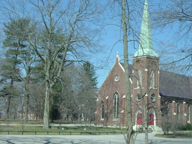
Middletown United Methodist Church
Church

Photo: Nyttend, Public domain.
The Middletown United Methodist Church is a historic church at Madison and Main Streets in Middletown, Kentucky. It was added to the National Register of Historic Places in 1980. Middletown United Methodist Church is situated 2½ miles south of 29.
Places in the Area
Nearby places include Lakeland and Anchorage.
Lakeland
Hamlet
Lakeland is a neighborhood of Louisville, Kentucky, located along LaGrange Road near Central State Hospital and Keeneland, Lyndon, Kentucky.
Anchorage
Village
 Anchorage is a home rule-class city in eastern Jefferson County, Kentucky, United States. The population was 2,500 as of the 2020 census, up from 2,348 at the 2010 census and an estimated 2,432 in 2018.
Keeneland
Hamlet
Keeneland is a former city in Jefferson County, Kentucky, United States, that was dissolved on January 1, 2001, and annexed by the neighboring City of Lyndon. Keeneland is now a neighborhood of Lyndon and also a part of Louisville Metro.
29
- Type: Scenic viewpoint
- Category: tourism
- Location: Jefferson, Kentucky, South, United States, North America
- View on OpenStreetMap
Latitude
38.27946° or 38° 16′ 46″ northLongitude
-85.544° or 85° 32′ 38″ westOpen location code
86CP7FH4+QCOpenStreetMap ID
node 7647301187OpenStreetMap feature
tourism=viewpoint
This page is based on OpenStreetMap, Wikidata, and Wikimedia Commons.
We’d love your help improving our open data sources. Thank you for contributing.
Satellite Map
Discover 29 from above in high-definition satellite imagery.
Notable Places Nearby
Highlights include 24 and 30.
Nearby Places
Explore places such as Willow Lake Tavern and Selena’s.
Kentucky: Must-Visit Destinations
Delve into Frankfort, Louisville, Lexington, and Bowling Green.
Curious Scenic Viewpoints to Discover
Uncover intriguing scenic viewpoints from every corner of the globe.
About Mapcarta. Data © OpenStreetMap contributors and available under the Open Database License". Text is available under the CC BY-SA 4.0 license, except for photos, directions, and the map. Photo: Wikimedia, CC BY-SA 2.0.