Freiwillige Feuerwehr Sandkrug
Freiwillige Feuerwehr Sandkrug is a fire station in Hatten, Oldenburg, Lower Saxony which is located on Löwenzahnweg. Freiwillige Feuerwehr Sandkrug is situated nearby to Schützenverein Sandkrug e.V., as well as near the sports venue Turnhalle.| Tap on a place to explore it |
Places of Interest Nearby
Highlights include Sandkrug station and Oldenburg-Hatten airfield.
Sandkrug station
Railway station
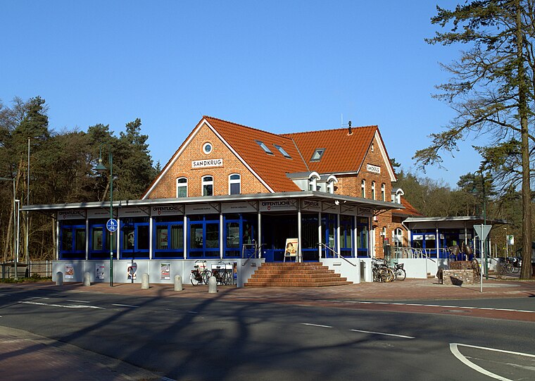
Photo: Jacek79, CC BY-SA 4.0.
Sandkrug station is a railway station in the municipality of Sandkrug, located in the Oldenburg district in Lower Saxony, Germany. Sandkrug station is situated 1 km west of Freiwillige Feuerwehr Sandkrug.
Oldenburg-Hatten airfield
Aerodrome

Photo: Carsten Steger, CC BY-SA 4.0.
Oldenburg-Hatten airfield is an aerodrome, which is situated 3 km northeast of Freiwillige Feuerwehr Sandkrug.
Barneführer Holz und Schreensmoor
Nature reserve

Photo: Muschelschubser, CC BY-SA 3.0.
Barneführer Holz und Schreensmoor is a nature reserve, which is situated 4 km south of Freiwillige Feuerwehr Sandkrug.
Places in the Area
Nearby places include Sandkrug and Astrup.
Astrup
Village
 Astrup is a village, which is situated 3 km southwest of Freiwillige Feuerwehr Sandkrug.
Osenberge
Locality
The Osenberge is a dune region up to 23 m above sea level high in the district of Oldenburg, Lower Saxony. Osenberge is situated 3½ km south of Freiwillige Feuerwehr Sandkrug.
Freiwillige Feuerwehr Sandkrug
- Type: Fire station
- Address: Löwenzahnweg 1, Streekermoor, Hatten, 26209
- Location: Hatten, Oldenburg, Lower Saxony, Germany, Central Europe, Europe
- View on OpenStreetMap
Latitude
53.05613° or 53° 3′ 22″ northLongitude
8.27086° or 8° 16′ 15″ eastOpen location code
9F5C374C+F8OpenStreetMap ID
node 7714320950OpenStreetMap feature
amenity=fire_station
This page is based on OpenStreetMap, Wikidata, and Wikimedia Commons.
We’d love your help improving our open data sources. Thank you for contributing.
Satellite Map
Discover Freiwillige Feuerwehr Sandkrug from above in high-definition satellite imagery.
Places with the Same Name
Discover other places named “Freiwillige Feuerwehr Sandkrug”.
Notable Places Nearby
Highlights include Schützenverein Sandkrug e.V. and Turnhalle.
Nearby Places
Explore places such as Freiwillige Feuerwehr Sandkrug and Kindertagesstätte Löwenzahn.
Lower Saxony: Must-Visit Destinations
Delve into Hanover, Göttingen, Brunswick, and Wolfsburg.
Curious Fire Stations to Discover
Uncover intriguing fire stations from every corner of the globe.
About Mapcarta. Data © OpenStreetMap contributors and available under the Open Database License". Text is available under the CC BY-SA 4.0 license, except for photos, directions, and the map. Photo: Danapit, CC BY-SA 3.0.