Sołtysia Skałka
Sołtysia Skałka is a peak in Gmina Czorsztyn, Nowy Targ County, Małopolskie and has an elevation of 582 metres. Sołtysia Skałka is situated nearby to the hamlet Glinik, as well as near the village Sromowce Wyżne.| Tap on a place to explore it |
Places of Interest
Highlights include Pieniński National Park and Niedzica Castle.
Pieniński National Park

Photo: Qvidemus, CC BY-SA 3.0 pl.
Pieniny National Park is in Poland. Pieniny National Park is a protected area located in the heart of Pieniny Mountains in the southernmost part of Poland. Administratively, the Park lies in the Lesser Poland voivodeship on the border with Slovakia.
Niedzica Castle
Castle
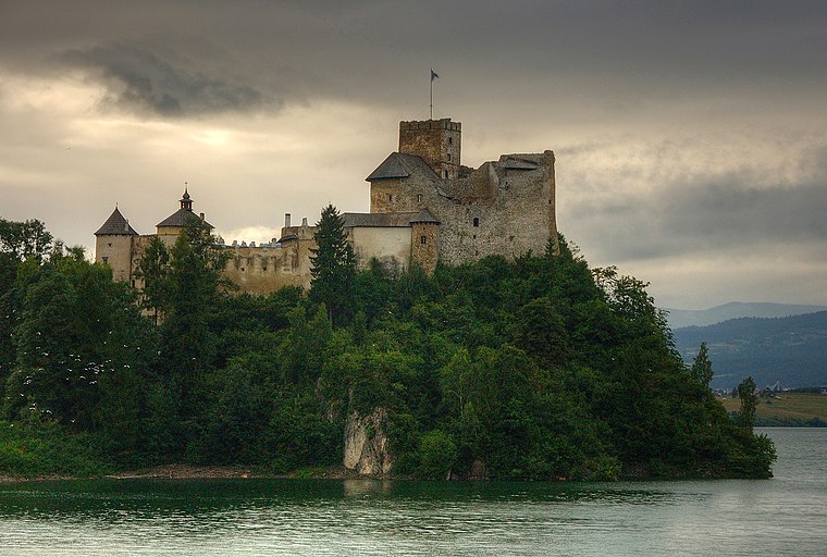
Photo: Smigly, CC BY-SA 3.0 pl.
Niedzica Castle, also known as Dunajec Castle, is located in the southernmost part of Poland in Niedzica. It was erected between the years 1320 and 1326 by Kokos of Brezovica on the site of an ancient stronghold surrounded by earthen walls in the Pieniny mountains.
Places in the Area
Nearby places include Niedzica and Beskids.
Niedzica

Photo: Wikimedia, CC BY-SA 3.0.
Niedzica is a resort village in Nowy Targ County of Lesser Poland province, Poland, located on the banks of Lake Czorsztyn. It is famous for Niedzica Castle, also known as Dunajec Castle.
Beskids

Photo: Lestat, CC BY-SA 3.0.
The Beskids are a long series of mountains, with over a dozen constituent ranges, that form part of the Carpathian Mountains. With peaks seldom exceeding 2000 m, they lie for the most part in southern Poland, crossing Silesia, Małopolskie and Podkarpackie Provinces.
Spišská Stará Ves
Town
 Spišská Stará Ves is a small town and urban municipality in Kežmarok District in the Prešov Region of north Slovakia.
Sołtysia Skałka
- Type: Peak with an elevation of 582 metres
- Category: landform
- Location: Gmina Czorsztyn, Nowy Targ County, Małopolskie, Poland, Central Europe, Europe
- View on OpenStreetMap
Latitude
49.4083° or 49° 24′ 30″ northLongitude
20.3412° or 20° 20′ 28″ eastElevation
582 metres (1,909 feet)Open location code
8GX2C85R+8FOpenStreetMap ID
node 7812266753OpenStreetMap feature
natural=peak
This page is based on OpenStreetMap, Wikidata, and Wikimedia Commons.
We’d love your help improving our open data sources. Thank you for contributing.
Satellite Map
Discover Sołtysia Skałka from above in high-definition satellite imagery.
Localities in the Area
Explore places such as Glinik and Sromowce Wyżne.
Notable Places Nearby
Highlights include Sołtysia Skała and Kalwaria Sromowska.
Małopolskie: Must-Visit Destinations
Delve into Kraków, Auschwitz-Birkenau, Oświęcim, and Zakopane.
Curious Peaks to Discover
Uncover intriguing peaks from every corner of the globe.
About Mapcarta. Data © OpenStreetMap contributors and available under the Open Database License". Text is available under the CC BY-SA 4.0 license, except for photos, directions, and the map. Photo: Sicherlich, CC BY 3.0.