Badeinsel Runkel
Badeinsel Runkel is a sports venue in Runkel, Limburg-Weilburg, Hesse. Badeinsel Runkel is situated nearby to the railway stop Runkel railway station, as well as near Lahn Bridge Runkel.| Tap on a place to explore it |
Places of Interest Nearby
Highlights include Lahn Bridge Runkel and Runkel Castle.
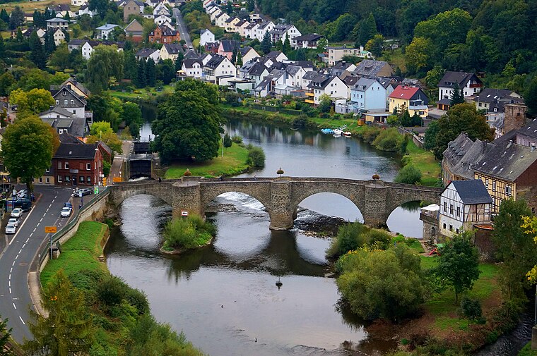
Runkel Castle

Photo: KlausFoehl, CC BY-SA 3.0.
Runkel Castle, a ruined hill castle from the High Middle Ages, is located in the city of Runkel in the Landkreis of Limburg-Weilburg in the state of Hesse. Runkel Castle is situated 150 metres northwest of Badeinsel Runkel.

Places in the Area
Nearby places include Limburg an der Lahn and Faulbach.
Limburg an der Lahn

Photo: Mr.Nutt, CC BY-SA 4.0.
Limburg an der Lahn is in Hesse. The town is famous for its marvellous mediaeval town centre with its timber-framed houses and its Dom.

Dauborn
Village

Photo: Hintertaunus, Public domain.
Dauborn is a village, which is situated 9 km south of Badeinsel Runkel.
Badeinsel Runkel
- Type: Sports venue
- Wheelchair access: no
- Categories: swimming, recreation area, and sports location
- Location: Runkel, Limburg-Weilburg, Giessen, Hesse, Germany, Central Europe, Europe
- View on OpenStreetMap
Latitude
50.40508° or 50° 24′ 18″ northLongitude
8.15839° or 8° 9′ 30″ eastOpen location code
9F2CC545+29OpenStreetMap ID
node 7858262716OpenStreetMap feature
leisure=sports_centreOpenStreetMap feature
sport=swimmingOpenStreetMap attribute
wheelchair=no
This page is based on OpenStreetMap, Wikidata, and Wikimedia Commons.
We’d love your help improving our open data sources. Thank you for contributing.
Satellite Map
Discover Badeinsel Runkel from above in high-definition satellite imagery.
Notable Places Nearby
Highlights include Burg Runkel and Rathaus Runkel.
Nearby Places
Explore places such as Zur Lahnbahn and ipunkt.
Hesse: Must-Visit Destinations
Delve into Frankfurt, Wiesbaden, Darmstadt, and Kassel.
Curious Sports Venues to Discover
Uncover intriguing sports venues from every corner of the globe.
About Mapcarta. Data © OpenStreetMap contributors and available under the Open Database License". Text is available under the CC BY-SA 4.0 license, except for photos, directions, and the map. Photo: Pedelecs, CC BY-SA 3.0.