Kožara
Kožara is a river island in Serbia, located on the left bank of the Danube. It is part of the Belgrade City proper and belongs to the Belgrade's municipality of Palilula.| Tap on a place to explore it |
Places of Interest Nearby
Highlights include Belgrade Fortress and Kalemegdan.
Belgrade Fortress
Castle

Photo: Wikimedia, CC BY-SA 3.0.
The Belgrade Fortress, consists of the old citadel and Kalemegdan Park on the confluence of the Sava and Danube rivers, in an urban area of modern Belgrade, Serbia. Belgrade Fortress is situated 2½ km south of Kožara.
Kalemegdan
Park

Photo: Laessig, CC BY-SA 3.0.
The Kalemegdan Park, or simply Kalemegdan is the largest park and the most important historical monument in Belgrade. It is located on a 125-metre-high cliff, at the junction of the River Sava and the Danube. Kalemegdan is situated 2½ km south of Kožara.
National Museum of Serbia
Museum
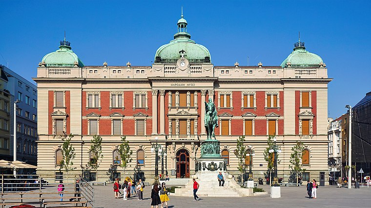
Photo: Simon04, CC BY-SA 4.0.
The National Museum of Serbia is the largest and oldest museum in Belgrade, Serbia. It is located in the central zone of Belgrade on a square plot between the Republic Square, formerly Theatre Square, and three streets: Čika Ljubina, Vasina and Laze Pačua. National Museum of Serbia is situated 3½ km south of Kožara.
Places in the Area
Nearby places include Kotež and Mika Alas.
Kotež
Quarter
Kotež is an urban neighborhood of Belgrade, the capital of Serbia. It is located in Belgrade's municipality of Palilula.
Mika Alas
Neighborhood
Mika Alas is an urban neighborhood of Belgrade, the capital of Serbia. It is located in Belgrade's municipality of Palilula.
Dunavski venac
Neighborhood
Dunavski Venac is an urban neighborhood of Belgrade, the capital of Serbia. It is located in Belgrade's municipality of Palilula, geographically located in Banat. Dunavski venac is situated 2½ km northeast of Kožara.
Kožara
- Type: Islet
- Description: island on the Danube river in Belgrade, Serbia
- Categories: river island, locality, and landform
- Location: Palilula, Belgrade, Central Serbia, Serbia, Balkans, Europe
- View on OpenStreetMap
Latitude
44.84633° or 44° 50′ 47″ northLongitude
20.4452° or 20° 26′ 43″ eastOpen location code
8GP2RCWW+G3OpenStreetMap ID
node 7885267296OpenStreetMap feature
place=isletWikidata ID
Q3199505
This page is based on OpenStreetMap, Wikidata, Wikimedia Commons, and Wikipedia.
We’d love your help improving our open data sources. Thank you for contributing.
Satellite Map
Discover Kožara from above in high-definition satellite imagery.
In Other Languages
From Dutch to Spanish—“Kožara” goes by many names.
Places with the Same Name
Discover other places named “Kožara”.
Notable Places Nearby
Highlights include Шљункара Бами and Дечји базен.
Nearby Places
Explore places such as Пумпа and Цвећара.
Serbia: Must-Visit Destinations
Delve into Novi Sad, Niš, Kragujevac, and Subotica.
Curious Islets to Discover
Uncover intriguing islets from every corner of the globe.
About Mapcarta. Data © OpenStreetMap contributors and available under the Open Database License". Text is available under the CC BY-SA 4.0 license, except for photos, directions, and the map. Description text is based on the Wikipedia page “Kožara”. Photo: Wikimedia, CC BY 3.0.