SMUR Saint-Malo
SMUR Saint-Malo is a doctor’s office in Saint-Malo, Ille-et-Vilaine, Brittany which is located on Rue de la Marne. SMUR Saint-Malo is situated nearby to Centre hospitalier de Saint-Malo, as well as near the church Chapelle Notre adresse Dame de Lourdes.| Tap on a place to explore it |
- Opening hours: 24/7
- Type: Doctor’s office
- Address: 1 Rue de la Marne, Saint-Malo, 35400
Places of Interest Nearby
Highlights include Malouinière de la Verderie and Saint-Malo station.
Malouinière de la Verderie
Manor estate

Photo: Wikimedia, Public domain.
Malouinière de la Verderie is a manor estate, which is situated 470 metres southwest of SMUR Saint-Malo.
Saint-Malo station
Railway station
 Saint-Malo station is a railway station serving the town Saint-Malo, Ille-et-Vilaine department, western France. The station is situated on the Rennes–Saint-Malo railway. Saint-Malo station is situated 1 km north of SMUR Saint-Malo.
Solidor Tower
Castle
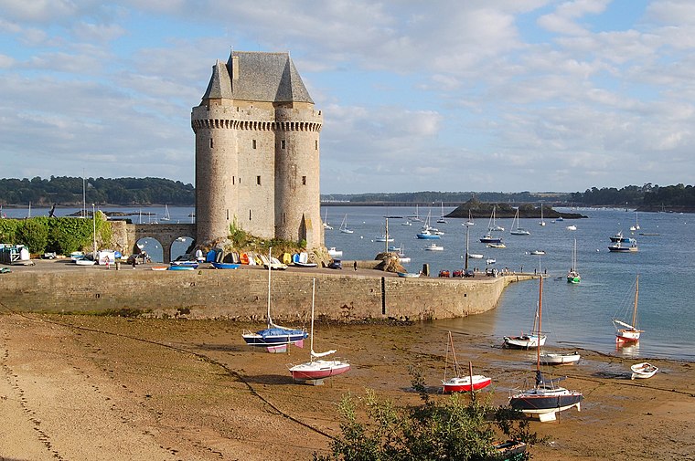
Photo: Pline, CC BY-SA 3.0.
Solidor Tower is a strengthened keep with three linked towers, located in the estuary of the river Rance in Brittany. It was built between 1369 and 1382 by John IV, Duke of Brittany to control access to the Rance at a time when the city of Saint-Malo did not recognize his authority. Solidor Tower is situated 1½ km west of SMUR Saint-Malo.
Places in the Area
Nearby places include Paramé and Saint-Ideuc.
Paramé
Suburb

Photo: TCY, CC BY-SA 2.5.
Paramé is a former town and commune of France on the north coast of Brittany. Paramé merged with Saint-Servan to form the commune of Saint-Malo in 1967. Paramé is situated 3 km northeast of SMUR Saint-Malo.
Saint-Ideuc
Suburb

Photo: Pymouss, CC BY-SA 3.0.
Saint-Ideuc is a suburb, which is situated 3½ km northeast of SMUR Saint-Malo.
Dinard

Photo: Diliff, CC BY-SA 3.0.
Dinard is a French commune on the Côte d'Émeraude of Brittany. Its beaches and mild climate make it a holiday destination. With its international film festival, villas, sumptuous hotels and casino, Dinard is regarded as one of the most prestigious seaside resorts in all of France.
SMUR Saint-Malo
- Category: health care
- Location: Saint-Malo, Arrondissement of Saint-Malo, Ille-et-Vilaine, Brittany, France, Europe
- View on OpenStreetMap
Latitude
48.63822° or 48° 38′ 18″ northLongitude
-2.00842° or 2° 0′ 30″ westOperator
CH Saint-MaloOpen location code
8CWVJXQR+7JOpenStreetMap ID
node 8201931710OpenStreetMap feature
amenity=doctorsOpenStreetMap feature
healthcare=doctor
This page is based on OpenStreetMap, Wikidata, and Wikimedia Commons.
We’d love your help improving our open data sources. Thank you for contributing.
Satellite Map
Discover SMUR Saint-Malo from above in high-definition satellite imagery.
Notable Places Nearby
Highlights include Centre hospitalier de Saint-Malo and Chapelle Notre adresse Dame de Lourdes.
Nearby Places
Explore places such as CeGIDD - CH - Saint Malo and Hôpital.
Brittany: Must-Visit Destinations
Delve into Rennes, Brest, Finistère, and Morbihan.
Curious Doctor’s Offices to Discover
Uncover intriguing doctor’s offices from every corner of the globe.
About Mapcarta. Data © OpenStreetMap contributors and available under the Open Database License". Text is available under the CC BY-SA 4.0 license, except for photos, directions, and the map. Photo: JLPC, CC BY-SA 3.0.