Hiršmandel
Hiršmandel is a neighborhood in Bratislava-Staré Mesto, Bratislava 1, Bratislava Region. Hiršmandel is situated nearby to the neighborhood Desiatky, as well as near Brojndel.| Tap on a place to explore it |
Places of Interest
Highlights include Bratislava hlavná stanica and Museum of Transport.
Bratislava hlavná stanica
Railway station

Photo: Yusuke Kawasaki, CC BY 2.0.
Bratislava hlavná stanica is the main railway station of the city of Bratislava, Slovakia. It averages about 60,000 passengers per day. Apart from domestic routes, international routes from this station include trains to Austria, Croatia, the Czech Republic, Germany, Hungary, Poland, Serbia, and Switzerland.
Museum of Transport
Museum

Photo: Pudelek, CC BY-SA 4.0.
Bratislava Transport Museum is a transport museum in Bratislava, Slovakia. It is a branch of the Slovak Technical Museum in Košice, is situated on the site of the first steam-railway station in Bratislava on Šancová Street, near the current main railway station in central Bratislava.
Bratislava Castle
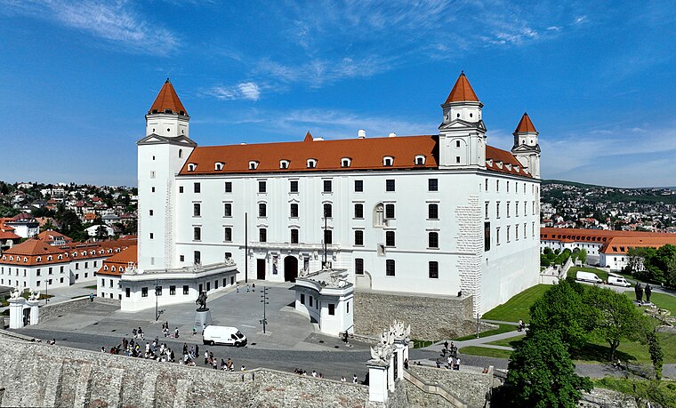
Photo: Bwag, CC BY-SA 4.0.
Bratislava Castle is the main castle of Bratislava, the capital of Slovakia. The massive rectangular building with four corner towers stands on an isolated rocky hill of the Little Carpathians, directly above the Danube river, in the middle of Bratislava.
Places in the Area
Nearby places include Stráže and Bratislava.

Bratislava

Photo: Tauba, CC BY-SA 3.0.
Bratislava, is the capital and largest city of Slovakia. It has a population of more than 475,000, and is the administrative, cultural and economic centre of the country.

Hiršmandel
- Type: Neighborhood
- Category: locality
- Location: Bratislava-Staré Mesto, Bratislava 1, Bratislava Region, Slovakia, Central Europe, Europe
- View on OpenStreetMap
Latitude
48.15781° or 48° 9′ 28″ northLongitude
17.11062° or 17° 6′ 38″ eastOpen location code
8FWV5456+46OpenStreetMap ID
node 8274323963OpenStreetMap feature
place=neighbourhood
This page is based on OpenStreetMap, Wikidata, and Wikimedia Commons.
We’d love your help improving our open data sources. Thank you for contributing.
Satellite Map
Discover Hiršmandel from above in high-definition satellite imagery.
In Other Languages
“Hiršmandel” goes by many names.
- German: “Hirschemandln”
Localities in the Area
Explore places such as Desiatky and Brojndel.
Notable Places Nearby
Highlights include Slovenský zväz bytových družstiev and Výbeh psov - Palárikova ulica.
Slovakia: Must-Visit Destinations
Delve into Bratislava, Košice, Banská Bystrica, and Prešov.
Curious Neighborhoods to Discover
Uncover intriguing neighborhoods from every corner of the globe.
About Mapcarta. Data © OpenStreetMap contributors and available under the Open Database License". Text is available under the CC BY-SA 4.0 license, except for photos, directions, and the map. Photo: Danapit, CC BY-SA 3.0.