Kreuzweg Alsberg 1
Kreuzweg Alsberg 1 is a wayside cross in Bad Soden-Salmünster, Gelnhausen, Hesse. Kreuzweg Alsberg 1 is situated nearby to the summer camp facility Jugendzeltplatz Bad Soden Salmünster, as well as near the playground Waldspielplatz Mühlwiese.| Tap on a place to explore it |
Places of Interest Nearby
Highlights include Waldweiher bei Bad Soden-Salmünster and Alsberger Hang.
Waldweiher bei Bad Soden-Salmünster
Nature reserve

Photo: SergejTruschkin, CC BY-SA 4.0.
Waldweiher bei Bad Soden-Salmünster is a nature reserve.
Alsberger Hang
Protected area
 Alsberger Hang is a protected area, which is situated 2 km southeast of Kreuzweg Alsberg 1.

Places in the Area
Nearby places include Bad Orb and Neudorf.
Bad Orb
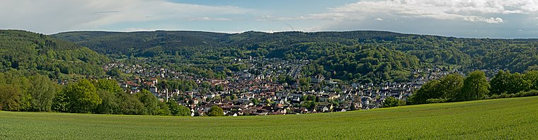
Photo: Milseburg, CC BY-SA 4.0.
Bad Orb is a spa town in North Hesse in the forested hills of the Spessart. Besides health facilities, there's an old town, remains of a medieval town wall, and hiking and biking trails.
Neudorf
Village

Photo: Björn, CC BY-SA 3.0.
Neudorf is a village, which is situated 7 km west of Kreuzweg Alsberg 1.

Kreuzweg Alsberg 1
- Type: Wayside cross
- Category: historic site
- Location: Bad Soden-Salmünster, Gelnhausen, South Hesse, Hesse, Germany, Central Europe, Europe
- View on OpenStreetMap
Latitude
50.26694° or 50° 16′ 1″ northLongitude
9.41221° or 9° 24′ 44″ eastOpen location code
9F2F7C86+QVOpenStreetMap ID
node 835716990OpenStreetMap feature
historic=wayside_cross
This page is based on OpenStreetMap, Wikidata, and Wikimedia Commons.
We’d love your help improving our open data sources. Thank you for contributing.
Satellite Map
Discover Kreuzweg Alsberg 1 from above in high-definition satellite imagery.
Notable Places Nearby
Highlights include Jugendzeltplatz Bad Soden Salmünster and Waldspielplatz Mühlwiese.
Nearby Places
Explore places such as Kreuzweg Alsberg 2 and Kreuzweg Alsberg 3.
South Hesse: Must-Visit Destinations
Delve into Darmstadt, Bensheim, Lorsch, and Heppenheim.
Curious Wayside Crosses to Discover
Uncover intriguing wayside crosses from every corner of the globe.
About Mapcarta. Data © OpenStreetMap contributors and available under the Open Database License". Text is available under the CC BY-SA 4.0 license, except for photos, directions, and the map. Photo: Lumpeseggl, CC BY-SA 3.0.