Wegkapelle hl. Florian, Dürnbach
Wegkapelle hl. Florian, Dürnbach is a wayside shrine in Schachendorf, Oberwart District, Burgenland. Wegkapelle hl. Florian, Dürnbach is situated nearby to the village Dürnbach im Burgenland, as well as near the tower Glockenstuhl/Wetterturm, Dürnbach.| Tap on a place to explore it |
Photo: Ueb-at, CC BY-SA 3.0.
Places of Interest Nearby
Highlights include Pfarrkirche Dürnbach and Glockenstuhl/Wetterturm, Dürnbach.
Pfarrkirche Dürnbach
Church
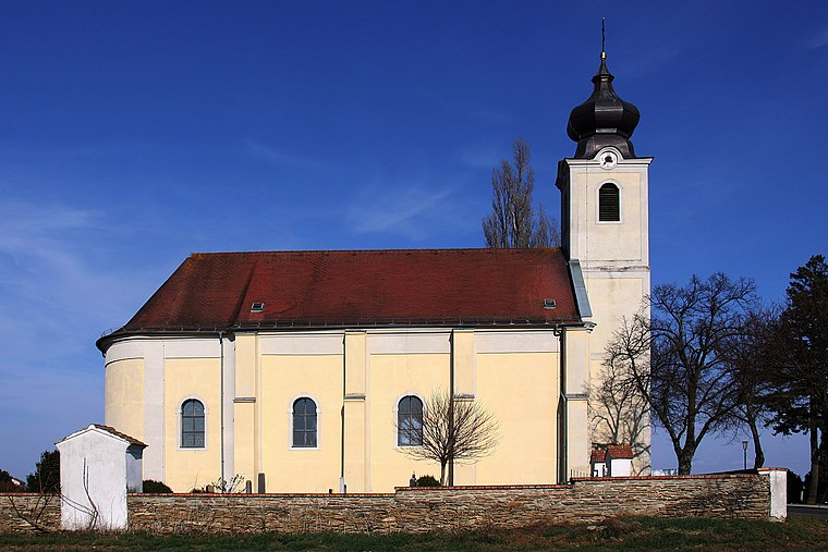
Photo: Steindy, CC BY-SA 3.0.
Pfarrkirche Dürnbach is a church, which is situated 1 km north of Wegkapelle hl. Florian, Dürnbach.
Glockenstuhl/Wetterturm, Dürnbach
Tower

Photo: Steindy, CC BY-SA 3.0.
Glockenstuhl/Wetterturm, Dürnbach is a tower, which is situated 500 metres northwest of Wegkapelle hl. Florian, Dürnbach.
Pfarrkirche hl. Anna, Schandorf
Church

Photo: Steindy, CC BY-SA 4.0.
Pfarrkirche hl. Anna, Schandorf is a church, which is situated 3 km southeast of Wegkapelle hl. Florian, Dürnbach.
Places in the Area
Nearby places include Dürnbach im Burgenland and Welgersdorf.
Dürnbach im Burgenland
Village
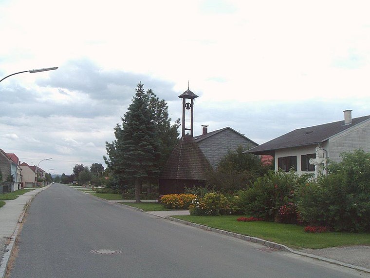
Photo: Wikimedia, Public domain.
Dürnbach im Burgenland is a village.
Welgersdorf
Village

Photo: Maximilian.schodisch, CC BY-SA 4.0.
Welgersdorf is a village, which is situated 4½ km southwest of Wegkapelle hl. Florian, Dürnbach.
Kisnarda
Hamlet

Photo: Nxr-at, CC BY-SA 4.0.
Kisnarda is a hamlet, which is situated 5 km southeast of Wegkapelle hl. Florian, Dürnbach.
Wegkapelle hl. Florian, Dürnbach
- Type: Wayside shrine
- Description: building in Schachendorf, Austria
- Categories: chapel and historic site
- Location: Schachendorf, Oberwart District, Burgenland, Austria, Central Europe, Europe
- View on OpenStreetMap
Latitude
47.26139° or 47° 15′ 41″ northLongitude
16.3938° or 16° 23′ 38″ eastOpen location code
8FVR796V+HGOpenStreetMap ID
node 8371213646OpenStreetMap feature
historic=wayside_shrineWikidata ID
Q38128347
This page is based on OpenStreetMap, Wikidata, and Wikimedia Commons.
We’d love your help improving our open data sources. Thank you for contributing.
Satellite Map
Discover Wegkapelle hl. Florian, Dürnbach from above in high-definition satellite imagery.
In Other Languages
“Wegkapelle hl. Florian, Dürnbach” goes by many names.
- German: “Wegkapelle hl. Florian”
Notable Places Nearby
Highlights include Kleindickicht and Suttenwald.
Nearby Places
Explore places such as Dürnbach im Burgenland Süd and Dürnbach im Burgenland Süd.
Burgenland: Must-Visit Destinations
Delve into Eisenstadt, Neusiedl am See, Rust, and Güssing.
Curious Wayside Shrines to Discover
Uncover intriguing wayside shrines from every corner of the globe.
About Mapcarta. Data © OpenStreetMap contributors and available under the Open Database License". Text is available under the CC BY-SA 4.0 license, except for photos, directions, and the map. Photo: Ueb-at, CC BY-SA 3.0.