Vaduz Lochgass
Vaduz Lochgass is a bus stop in Vaduz, Liechtenstein. Vaduz Lochgass is situated nearby to the fire station Feuerwehr Vaduz, as well as near the government office Schwedisches Honorarkonsulat.| Tap on a place to explore it |
Places of Interest Nearby
Highlights include Rheinpark Stadion and Johanneskirche.
Rheinpark Stadion
Pitch

Photo: Wikimedia, CC BY-SA 3.0.
Rheinpark Stadion in Vaduz is the national stadium of Liechtenstein. It plays host to home matches of the Liechtenstein national football team, and is also the home of football club FC Vaduz. Rheinpark Stadion is situated 710 metres south of Vaduz Lochgass.
Johanneskirche
Church

Photo: Maimaid, CC BY-SA 4.0.
Johanneskirche is a church, which is situated 200 metres northwest of Vaduz Lochgass.
Kunstmuseum Liechtenstein
Museum
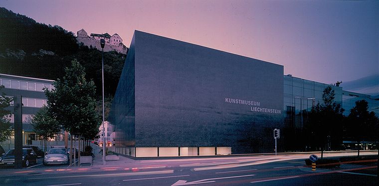
Photo: Wikimedia, CC BY-SA 3.0.
The Kunstmuseum Liechtenstein is a state art museum in Vaduz, Liechtenstein. The building by the Swiss architects Meinrad Morger, Heinrich Degelo and Christian Kerez was completed in November 2000. Kunstmuseum Liechtenstein is situated 1¼ km southeast of Vaduz Lochgass.
Places in the Area
Nearby places include Ebenholz and Mühleholz.
Ebenholz
Village
Ebenholz is a village of Liechtenstein, located in the municipality of Vaduz. Its name means "ebony" in German.
Mühleholz
Village

Photo: Wikimedia, CC BY-SA 4.0.
Mühleholz is an Ortsteil in Liechtenstein located in the municipality of Vaduz.
Schaan

Photo: Ypsilon from Finland, CC0.
Schaan is the largest municipality of Liechtenstein by population. It is located to the north of Vaduz, the capital, in the central part of the country.
Vaduz Lochgass
- Type: Bus stop
- Category: transportation
- Location: Vaduz, Liechtenstein, Central Europe, Europe
- View on OpenStreetMap
Latitude
47.14693° or 47° 8′ 49″ northLongitude
9.51066° or 9° 30′ 38″ eastElevation
454 metres (1,490 feet)Operator
LIEmobilOpen location code
8FVF4GW6+Q7OpenStreetMap ID
node 8423202944OpenStreetMap feature
highway=bus_stopOpenStreetMap feature
public_transport=platform
This page is based on OpenStreetMap, Wikidata, and Wikimedia Commons.
We’d love your help improving our open data sources. Thank you for contributing.
Satellite Map
Discover Vaduz Lochgass from above in high-definition satellite imagery.
Notable Places Nearby
Highlights include Feuerwehr Vaduz and Dänisches Honorarkonsulat.
Nearby Places
Explore places such as Vaduz Lochgass and Vaduz Bartlegrosch.
Curious Bus Stops to Discover
Uncover intriguing bus stops from every corner of the globe.
About Mapcarta. Data © OpenStreetMap contributors and available under the Open Database License". Text is available under the CC BY-SA 4.0 license, except for photos, directions, and the map. Photo: Wikimedia, CC BY-SA 2.5.