Menhir de l’Eglise
Menhir de l’Eglise is an archaeological site in Clohars-Carnoët, Arrondissement of Quimper, Brittany. Menhir de l’Eglise is situated nearby to the church Église Notre-Dame-de-Trogwall de Clohars-Carnoët, as well as near Place Général de Gaulle.| Tap on a place to explore it |
Places of Interest Nearby
Highlights include Église Notre-Dame-de-Trogwall de Clohars-Carnoët and Chapelle Saint-Jacques de Clohars-Carnoët.
Église Notre-Dame-de-Trogwall de Clohars-Carnoët
Church

Photo: Moreau.henri, CC BY-SA 4.0.
Église Notre-Dame-de-Trogwall de Clohars-Carnoët is a church.
Chapelle Saint-Jacques de Clohars-Carnoët
Church

Photo: Moreau.henri, CC BY-SA 4.0.
Chapelle Saint-Jacques de Clohars-Carnoët is a church, which is situated 1 km south of Menhir de l’Eglise.
Menhir de Mescleo
Archaeological site
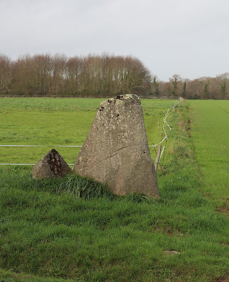
Photo: Wikimedia, CC BY-SA 4.0.
Menhir de Mescleo is an archaeological site, which is situated 2½ km west of Menhir de l’Eglise.
Places in the Area
Nearby places include Moëlan-sur-Mer and Guidel.
Moëlan-sur-Mer
Village

Photo: Julien1978, CC BY-SA 3.0.
Moëlan-sur-Mer is a commune in the Finistère department and administrative region of Brittany in north-western France. Moëlan-sur-Mer is situated 4 km northwest of Menhir de l’Eglise.
Guidel
Town

Photo: Manou56, CC BY-SA 3.0.
Guidel is a commune in the Morbihan department of Brittany in north-western France. Inhabitants of Guidel are called in French Guidélois. Guidel is situated 7 km east of Menhir de l’Eglise.
Quimperlé
Town

Photo: Moreau.henri, CC BY-SA 4.0.
Quimperlé is a commune in the Finistère department, region of Brittany, northwestern France. Quimperlé is situated 9 km north of Menhir de l’Eglise.
Menhir de l’Eglise
- Type: Archaeological site
- Categories: historic site, tourist attraction, and tourism
- Location: Clohars-Carnoët, Arrondissement of Quimper, Finistère, Brittany, France, Europe
- View on OpenStreetMap
Latitude
47.79634° or 47° 47′ 47″ northLongitude
-3.58593° or 3° 35′ 9″ westElevation
72 metres (236 feet)Open location code
8CVRQCW7+GJOpenStreetMap ID
node 8456378428OpenStreetMap feature
historic=archaeological_site
This page is based on OpenStreetMap, Wikidata, and Wikimedia Commons.
We’d love your help improving our open data sources. Thank you for contributing.
Satellite Map
Discover Menhir de l’Eglise from above in high-definition satellite imagery.
Notable Places Nearby
Highlights include Place Général de Gaulle and Mairie de Clohars-Carnoët.
Nearby Places
Explore places such as Cap Conduite and Caro & Francesco.
Brittany: Must-Visit Destinations
Delve into Rennes, Brest, Finistère, and Morbihan.
Curious Archaeological Sites to Discover
Uncover intriguing archaeological sites from every corner of the globe.
About Mapcarta. Data © OpenStreetMap contributors and available under the Open Database License". Text is available under the CC BY-SA 4.0 license, except for photos, directions, and the map. Photo: Spendeau, CC BY-SA 3.0.