Wulitun
Wulituo Subdistrict is a subdistrict situated on the northwestern part of Shijingshan District, Beijing, China. It shares border with Junzhuang Town and Xiangshan Subdistrict to the north, Pingguoyuan Subdistrict and Sijiqing Township to the east, Jinding Street and Guangning Subdistricts to the south, as well as Chengzi Subdistrict and Longquan Township to the west.| Tap on a place to explore it |
- Type: Suburb
- Description: subdistrict in Beijing, China
- Also known as: “Wulituo Subdistrict”
Places of Interest
Highlights include Sanjiadian and #53.
Sanjiadian
Railway station

Photo: N509FZ, CC BY-SA 4.0.
Sanjiadian railway station is a railway station in Mentougou District, Beijing on the Fengtai–Shacheng railway, Beijing–Mentougou railway and Beijing Northwest Ring railway. It was opened in 1907.
#53
Railway stop
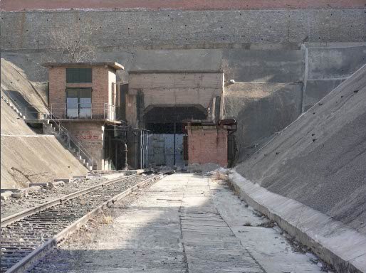
Photo: Wikimedia, CC BY-SA 3.0.
Station 53, also known as Gaojing Station and Wusan Station, formerly known as Fushouling Station, is the westernmost station in the underground section of Beijing Metro Line 1 in its early planning. #53 is situated 2½ km east of Wulitun.
Moshikou
Metro station

Photo: Wikimedia, CC BY-SA 4.0.
Moshikou station is a subway station on Line 11 of the Beijing Subway. It opened on 30 December 2023, and is the northern terminus of the line. Moshikou is situated 3½ km southeast of Wulitun.
Places in the Area
Nearby places include Mentougou and Longquan.
Mentougou
 Mentougou District is a rural district in western Beijing Municipality. The district has mountainous terrain and Mount Ling the tallest peak in Beijing is situated in the district.
Longquan
Town
Longquan Town is a town that lies on the eastern side of Mentougou District, Beijing, China. It borders Miaofengshan and Junzhuang Towns to the north, Wulituo and Guangning Subdistricts to the east, Yongding and Tantuo Towns to the south, Yongding and Wangping to the west. Longquan is situated 3 km southwest of Wulitun.
Junzhuang
Town
Junzhuang Town is a town on northeastern Mentougou District, Beijing, China. It is located on the south of Sujiatuo and Wenquan Towns, west of Xiangshan Subdistrict, north of Wulituo Subdistrict and Longquan Town, and East of Miaofengshan Town. Junzhuang is situated 6 km north of Wulitun.
Wulitun
- Categories: subdistrict in China and locality
- Location: Beijing, North China, China, East Asia, Asia
- View on OpenStreetMap
Latitude
39.95511° or 39° 57′ 18″ northLongitude
116.11991° or 116° 7′ 12″ eastOpen location code
8PFRX449+2XOpenStreetMap ID
node 8479221567OpenStreetMap feature
place=suburbWikidata ID
Q10882253
This page is based on OpenStreetMap, Wikidata, Wikimedia Commons, and Wikipedia.
We’d love your help improving our open data sources. Thank you for contributing.
Satellite Map
Discover Wulitun from above in high-definition satellite imagery.
In Other Languages
From Chinese to Wu Chinese—“Wulitun” goes by many names.
- Chinese: “五里坨街道”
- Chinese: “五里坨街道办事处”
- French: “sous-district de Wuli Tuo”
- French: “Sous-district de Wuli Tuo”
- Gan Chinese: “五里坨街道”
- Korean: “우리툰가도”
- Wu Chinese: “五里坨街道”
Places with the Same Name
Discover other places named “Wulitun”.
Localities in the Area
Explore places such as 敬德寺 and 新隆恩寺.
Notable Places Nearby
Highlights include 小青山公园 and 五里坨医院.
Beijing: Must-Visit Destinations
Delve into Forbidden City, Chaoyang, Xicheng, and Beijing Capital International Airport.
Curious Suburbs to Discover
Uncover intriguing suburbs from every corner of the globe.
About Mapcarta. Data © OpenStreetMap contributors and available under the Open Database License". Text is available under the CC BY-SA 4.0 license, except for photos, directions, and the map. Description text is based on the Wikipedia page “Wulitun”. Photo: Wikimedia, CC0.