Merkzeichen
Merkzeichen is a work of art in Hamburg, Hamburg. Merkzeichen is situated nearby to the church Freie evangelische Gemeinde Jenfeld, as well as near the school Schule Öjendorfer Damm.| Tap on a place to explore it |
Places of Interest Nearby
Highlights include Öjendorfer Park and Panflötenspieler.

Panflötenspieler
Work of art

Photo: Minderbinder, CC BY 4.0.
Panflötenspieler is a work of art, which is situated 1 km north of Merkzeichen.
Italian Military Cemetery
Memorial
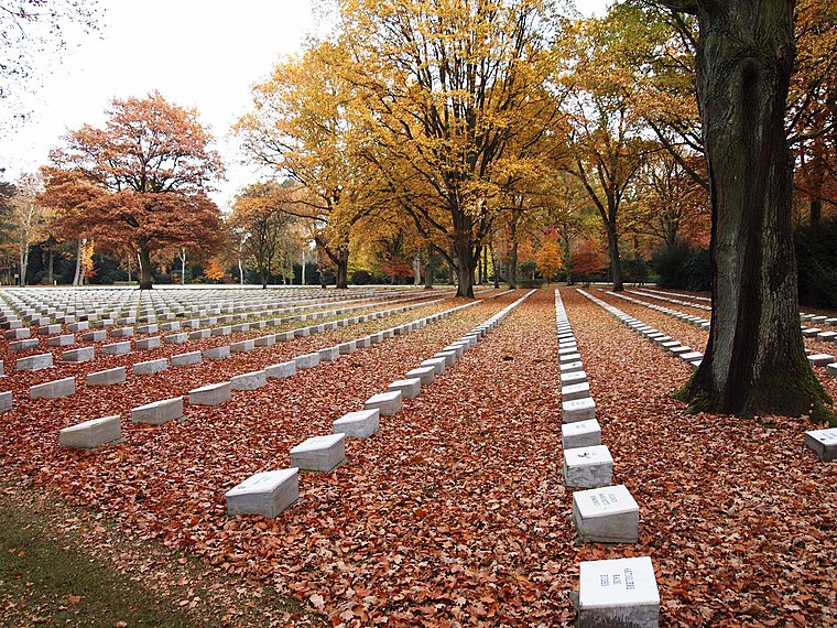
Photo: Roberto2381, CC BY-SA 4.0.
Italian Military Cemetery is a memorial, which is situated 1¼ km southwest of Merkzeichen.
Places in the Area
Nearby places include Jenfeld and Horn.
Jenfeld
Suburb

Photo: Wikimedia, Public domain.
Jenfeld is a quarter of Hamburg, Germany in the Wandsbek borough.
Horn
Suburb
 Horn is a district in the borough Hamburg-Mitte, in the eastern part of Hamburg, Germany. In 2020 the population was 37,903. Horn is situated 3½ km southwest of Merkzeichen.
Marienthal
Suburb

Photo: Pincerno, CC BY-SA 2.0 de.
Marienthal is a quarter of Hamburg, Germany in the Wandsbek borough. Marienthal is situated 3½ km west of Merkzeichen.
Merkzeichen
- Type: Work of art
- Artwork type: sculpture
- Category: tourism
- Location: Hamburg, Hamburg, Freie und Hansestadt, Hamburg, Germany, Central Europe, Europe
- View on OpenStreetMap
Latitude
53.56871° or 53° 34′ 7″ northLongitude
10.13743° or 10° 8′ 15″ eastInception
1971Open location code
9F5GH49P+FXOpenStreetMap ID
node 8487407701OpenStreetMap feature
tourism=artworkOpenStreetMap attribute
artwork_type=sculpture
This page is based on OpenStreetMap, Wikidata, and Wikimedia Commons.
We’d love your help improving our open data sources. Thank you for contributing.
Satellite Map
Discover Merkzeichen from above in high-definition satellite imagery.
Notable Places Nearby
Highlights include Merkzeichen and Freie evangelische Gemeinde Jenfeld.
Nearby Places
Explore places such as Wegweiser and Im-Export.
Hamburg: Must-Visit Destinations
Delve into Altona-St. Pauli, Neustadt-Altstadt, East Hamburg, and North Hamburg.
Curious Work Of Arts to Discover
Uncover intriguing work of arts from every corner of the globe.
About Mapcarta. Data © OpenStreetMap contributors and available under the Open Database License". Text is available under the CC BY-SA 4.0 license, except for photos, directions, and the map. Photo: Joerg Moellenkamp, CC BY 2.0.