Hatfield Government Center
Hatfield Government Center is a railway stop in Washington, Oregon. Hatfield Government Center is situated nearby to Hillsboro Post Office, as well as near the government office Washington County Center For Counseling and Victims’ Services.| Tap on a place to explore it |
Places of Interest Nearby
Highlights include Hillsboro Civic Center and Hatfield Government Center station.
Hillsboro Civic Center
Community center
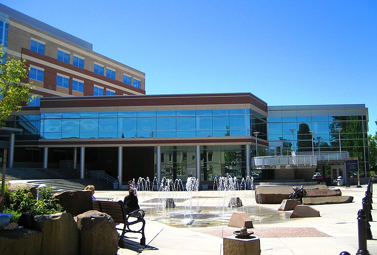
Photo: Aboutmovies, Public domain.
The Hillsboro Civic Center is a government-built, mixed-use development in downtown Hillsboro, Oregon, United States. The development includes the city hall for the county seat of Washington County, located west of Portland, Oregon. Hillsboro Civic Center is situated 480 feet east of Hatfield Government Center.
Hatfield Government Center station
Railway stop

Photo: Bruce Fingerhood, CC BY 2.0.
Hatfield Government Center is a light rail station in downtown Hillsboro, Oregon, United States, owned and operated by TriMet. The station is the western terminus of the MAX Blue Line.
Washington County Courthouse
Courthouse

Photo: Steve Morgan, CC BY-SA 4.0.
The Washington County Courthouse in Hillsboro, Oregon is the courthouse for Washington County, Oregon, in the United States. Washington County was established in 1843 and the first government building was finished in 1852. Washington County Courthouse is situated 700 feet northeast of Hatfield Government Center.
Places in the Area
Nearby places include Hillsboro and Cornelius.
Hillsboro

Photo: Aboutmovies, CC BY-SA 3.0.
Hillsboro is a city in the Portland Metropolitan Area in Oregon. It contains several districts such as hip and trendy Orenco in all of its high-density glory, along with more rural South Hillsboro, although the mayor's building program is building up this area into subdivisions as of 2022.
Cornelius
Town

Photo: Aboutmovies, CC BY-SA 3.0.
Cornelius is a city in Washington County, Oregon, United States. Located in the Portland metropolitan area, the city's population was 11,869 at the 2010 census. Cornelius is situated 3 miles west of Hatfield Government Center.
Witch Hazel
Suburb

Photo: Aboutmovies, CC BY 3.0.
Witch Hazel is a neighborhood of the city of Hillsboro in Washington County, Oregon, United States. Formerly an unincorporated community, and considered a separate populated place by the United States Geological Survey, it is on the Tualatin Valley Highway and the Southern Pacific railroad line a mile west of Reedville. Witch Hazel is situated 3½ miles southeast of Hatfield Government Center.
Hatfield Government Center
- Type: Railway stop
- Categories: transport stop and transportation
- Location: Washington, Oregon, Pacific Northwest, United States, North America
- View on OpenStreetMap
Latitude
45.52203° or 45° 31′ 19″ northLongitude
-122.99096° or 122° 59′ 28″ westNetwork
TriMetOpen location code
84QVG2C5+RJOpenStreetMap ID
node 8522750849OpenStreetMap feature
public_transport=stop_positionOpenStreetMap feature
railway=stop
This page is based on OpenStreetMap, Wikidata, and Wikimedia Commons.
We’d love your help improving our open data sources. Thank you for contributing.
Satellite Map
Discover Hatfield Government Center from above in high-definition satellite imagery.
Places with the Same Name
Discover other places named “Hatfield Government Center”.
Notable Places Nearby
Highlights include Hillsboro Post Office and Washington County Center For Counseling and Victims’ Services.
Nearby Places
Explore places such as Hatfield Government Center and Mark O. Hatfield Terminus.
Oregon: Must-Visit Destinations
Delve into Portland, Salem, Eugene, and Astoria.
Curious Railway Stops to Discover
Uncover intriguing railway stops from every corner of the globe.
About Mapcarta. Data © OpenStreetMap contributors and available under the Open Database License". Text is available under the CC BY-SA 4.0 license, except for photos, directions, and the map. Photo: Wikimedia, CC BY-SA 3.0.