Trancão (X) Zambujal
Trancão (X) Zambujal is a bus stop in Santo Antão e São Julião do Tojal, Loures, Lisbon District. Trancão (X) Zambujal is situated nearby to the archaeological site Bateria do Penedo, as well as near the protected area Forte do Tojal.| Tap on a place to explore it |
Places of Interest Nearby
Highlights include Bucelas Wine and Vineyard Museum and Palácio da Mitra, aqueduto, pombais, chafarizes, igreja, monumental portão de entrada e toda a área murada da antiga quinta.
Bucelas Wine and Vineyard Museum
Museum

Photo: Inesmmloures, CC BY-SA 4.0.
Bucelas Wine and Vineyard Museum is situated 3 km north of Trancão (X) Zambujal.
Palácio da Mitra, aqueduto, pombais, chafarizes, igreja, monumental portão de entrada e toda a área murada da antiga quinta
Castle
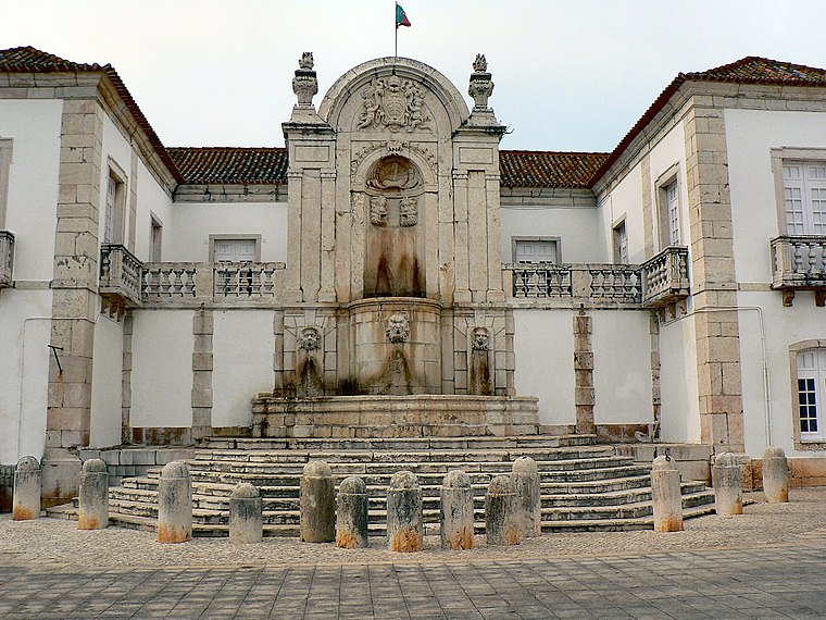
Photo: Juntas, CC BY-SA 2.5.
Palácio da Mitra, aqueduto, pombais, chafarizes, igreja, monumental portão de entrada e toda a área murada da antiga quinta is a castle, which is situated 3 km south of Trancão (X) Zambujal.
Fort of Ribas
Protected area

Photo: Roundtheworld, CC BY-SA 4.0.
The Fort of Ribas, also known as the Redoubt of Ribas and the Redoubt of Freixial Alto, is one of a group of fortifications in Portugal that made up the second of the three defensive Lines of Torres Vedras, between the Atlantic Ocean and the River Tagus, which were designed to protect the capital, Lisbon, from possible invasion by French troops during the Peninsular War. Fort of Ribas is situated 3½ km northwest of Trancão (X) Zambujal.
Places in the Area
Nearby places include Fanhões and Freguesia de Santo Antão do Tojal.

Freguesia de Santo Antão do Tojal
Village

Photo: Juntas, CC BY-SA 2.5.
Freguesia de Santo Antão do Tojal is a village, which is situated 3 km south of Trancão (X) Zambujal.
Bucelas
Town

Photo: Juntas, CC BY-SA 3.0.
Bucelas is a civil parish in the municipality of Loures, Portugal. The population in 2011 was 4,663, in an area of 33.97 km². The town is known for its Bucelas DOC wine. Bucelas is situated 3 km north of Trancão (X) Zambujal.
Trancão (X) Zambujal
- Type: Bus stop
- Category: transportation
- Location: Santo Antão e São Julião do Tojal, Loures, Lisbon District, Portugal, Iberia, Europe
- View on OpenStreetMap
Latitude
38.87729° or 38° 52′ 38″ northLongitude
-9.13088° or 9° 7′ 51″ westOperator
Rodoviária de LisboaNetwork
Carris MetropolitanaOpen location code
8CCGVVG9+WJOpenStreetMap ID
node 8666037229OpenStreetMap feature
highway=bus_stopOpenStreetMap feature
public_transport=platform
This page is based on OpenStreetMap, Wikidata, and Wikimedia Commons.
We’d love your help improving our open data sources. Thank you for contributing.
Satellite Map
Discover Trancão (X) Zambujal from above in high-definition satellite imagery.
Notable Places Nearby
Highlights include Bateria do Penedo and Forte do Tojal.
Nearby Places
Explore places such as Trancão (X) Zambujal and São Julião do Tojal.
Portugal: Must-Visit Destinations
Delve into Lisbon, Caldas da Rainha, Porto, and Coimbra.
Curious Bus Stops to Discover
Uncover intriguing bus stops from every corner of the globe.
About Mapcarta. Data © OpenStreetMap contributors and available under the Open Database License". Text is available under the CC BY-SA 4.0 license, except for photos, directions, and the map. Photo: Vitor Oliveira, CC BY-SA 2.0.