Neue Wege im Regionalpark
Neue Wege im Regionalpark is in Kelsterbach, Groß-Gerau, Hesse. Neue Wege im Regionalpark is situated nearby to the sports venue Sportstätte an der IGS Kelsterbach, as well as near the park Baugéplatz.| Tap on a place to explore it |
Places of Interest Nearby
Highlights include Frankfurt Airport and Frankfurt Airport long-distance station.
Frankfurt Airport

Photo: Epizentrum, CC BY-SA 3.0.
Frankfurt Airport is the largest airport in Germany and a global aviation hub on the outskirts of Frankfurt am Main in the state of Hesse.
Frankfurt Airport long-distance station
Railway station
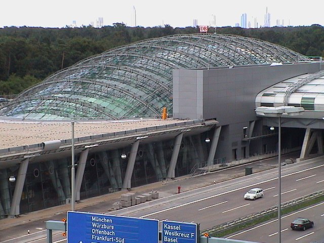
Photo: Wikimedia, CC BY-SA 3.0.
Frankfurt am Main Airport long-distance station is a railway station at Frankfurt Airport in Frankfurt, Germany. It is served by long-distance trains, mostly ICE services running on the Cologne–Frankfurt high-speed rail line. Frankfurt Airport long-distance station is situated 2 km east of Neue Wege im Regionalpark.
Frankfurt am Main Airport Regional trains
Railway station

Photo: Jivee Blau, CC BY-SA 3.0.
Frankfurt Airport regional station is an underground railway station at Frankfurt Airport in Frankfurt, Germany. It provides local S-Bahn and Regionalbahn services to the city and the Frankfurt/Rhine-Main Metropolitan Region. Frankfurt am Main Airport Regional trains is situated 2 km east of Neue Wege im Regionalpark.
Places in the Area
Nearby places include Schwedenschanze Kelsterbach and Kelsterbacher Terrasse.
Schwedenschanze Kelsterbach
Locality

Photo: Frank Winkelmann, CC BY 3.0.
Schwedenschanze Kelsterbach is a locality.
Kelsterbacher Terrasse
Locality

Photo: Frank Behnsen, CC BY-SA 3.0.
Kelsterbacher Terrasse is a locality.
Okriftel
Village

Photo: Karsten11, Public domain.
Okriftel is a village, which is situated 3½ km west of Neue Wege im Regionalpark.
Neue Wege im Regionalpark
- Type: Sign
- Categories: information and tourism
- Location: Kelsterbach, Groß-Gerau, South Hesse, Hesse, Germany, Central Europe, Europe
- View on OpenStreetMap
Latitude
50.05711° or 50° 3′ 26″ northLongitude
8.54592° or 8° 32′ 45″ eastOpen location code
9F2C3G4W+R9OpenStreetMap ID
node 8749179481OpenStreetMap feature
tourism=information
This page is based on OpenStreetMap, Wikidata, and Wikimedia Commons.
We’d love your help improving our open data sources. Thank you for contributing.
Satellite Map
Discover Neue Wege im Regionalpark from above in high-definition satellite imagery.
Notable Places Nearby
Highlights include Sportstätte an der IGS Kelsterbach and Baugéplatz.
Nearby Places
Explore places such as BG Grill 77 and Baugéstraße.
South Hesse: Must-Visit Destinations
Delve into Darmstadt, Bensheim, Lorsch, and Heppenheim.
Curious Places to Discover
Uncover intriguing places from every corner of the globe.
About Mapcarta. Data © OpenStreetMap contributors and available under the Open Database License". Text is available under the CC BY-SA 4.0 license, except for photos, directions, and the map. Photo: Mylius, GFDL.