Pumping Station #9
Pumping Station #9 is a pumping station in Rural Worcester County, Eastern Shore, Maryland which is located on Dukes Avenue. Pumping Station #9 is situated nearby to North Surf Park, as well as near Parasail Boat & Jetski Rentals.| Tap on a place to explore it |
Places of Interest Nearby
Highlights include Fenwick Island Light.
Fenwick Island Light
Lighthouse
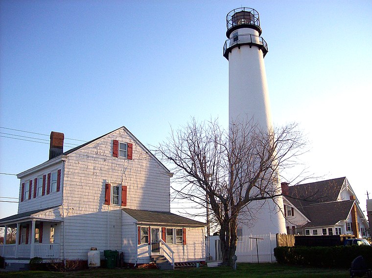
Photo: Lionsatthegate37, CC BY-SA 3.0.
Fenwick Island Lighthouse is a lighthouse in Delaware, United States, on the Delaware/Maryland state line. The structure dates back to 1858 making it the oldest lighthouse in the state of Delaware. Fenwick Island Light is situated 2,600 feet east of Pumping Station #9.
Places in the Area
Nearby places include Fenwick Island and Williamsville.
Fenwick Island

Photo: Lionsatthegate37, CC BY-SA 3.0.
Fenwick Island is a beach town in Sussex County, Delaware located north of Ocean City, Maryland, just over the Delaware border. The town is part of Delaware's beach resort area.
Williamsville
Neighborhood
Williamsville is an unincorporated community in Sussex County, Delaware, United States. Williamsville is located on Delaware Route 54 between Selbyville and Fenwick Island. It was the site of the Williamsville Colored School. Williamsville is situated 4 miles west of Pumping Station #9.
York Beach
Neighborhood
South Bethany is an incorporated town in Sussex County, Delaware, United States. According to the 2010 census, the population of the town is 449, a decrease of 8.7% over the previous decade. York Beach is situated 4 miles north of Pumping Station #9.
Pumping Station #9
- Type: Pumping station
- Address: 14106 Dukes Avenue, Ocean City, MD 21842
- Category: industry
- Location: Rural Worcester County, Eastern Shore, Maryland, Mid-Atlantic, United States, North America
- View on OpenStreetMap
Latitude
38.44948° or 38° 26′ 58″ northLongitude
-75.06381° or 75° 3′ 50″ westOpen location code
87C6CWXP+QFOpenStreetMap ID
node 8805499964OpenStreetMap feature
man_made=pumping_station
This page is based on OpenStreetMap, Wikidata, and Wikimedia Commons.
We’d love your help improving our open data sources. Thank you for contributing.
Satellite Map
Discover Pumping Station #9 from above in high-definition satellite imagery.
Notable Places Nearby
Highlights include North Surf Park and Fiesta Park.
Nearby Places
Explore places such as Lighthouse Village and Harpoon Hanna’s.
Eastern Shore: Must-Visit Destinations
Delve into Salisbury, Ocean City, Cambridge, and Easton.
Curious Pumping Stations to Discover
Uncover intriguing pumping stations from every corner of the globe.
About Mapcarta. Data © OpenStreetMap contributors and available under the Open Database License". Text is available under the CC BY-SA 4.0 license, except for photos, directions, and the map. Photo: Wikimedia, CC0.