Prince Ferdinand’s Battery
Prince Ferdinand's Battery was an artillery battery in the British Overseas Territory of Gibraltar. Today the area is known as the Apes' Den and is the main location for tourists to see Barbary macaques in Gibraltar.| Tap on a place to explore it |
Photo: HJ Mitchell, CC BY 3.0.
Places of Interest Nearby
Highlights include The Rock and Gibraltar Cable Car.
The Rock
Peak
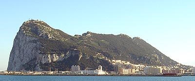
Photo: Gibnews, Public domain.
The Rock of Gibraltar is a monolithic limestone mountain 426 m high dominating the western entrance to the Mediterranean Sea. It is situated near the end of a narrow 9 kilometres -long promontory stretching due south into the Mediterranean Sea and is located within the British territory of Gibraltar.
Gibraltar Cable Car
Aerial lift

Photo: David Morris, CC BY 2.0.
Gibraltar Cable Car is an aerial tramway in Gibraltar. The base station of the cable car is located near the southern end of Main Street, next to Alameda Gardens. Gibraltar Cable Car is situated 140 metres north of Prince Ferdinand’s Battery.
The Rock Hotel
Hotel
 The Rock Hotel, also known as Rock Hotel, is a historic hotel in the British Overseas Territory of Gibraltar. It has been described as "one of the Mediterranean's most famous hotels," and as "an institution in Gibraltar and the Mediterranean." Built in 1932 by John Crichton-Stuart, 4th Marquess of Bute, the hotel is set in a 3.6-hectare landscaped garden and contains 104 rooms. The Rock Hotel is situated 120 metres west of Prince Ferdinand’s Battery.
Places in the Area
Nearby places include Coaling Island and East Side.
Coaling Island
Locality

Photo: Mrjohncummings, CC BY-SA 3.0.
Coaling Island is an area of reclaimed land in the British Overseas Territory of Gibraltar. It is located at the centre of the western end of Gibraltar Harbour as one of its industrial zones.
East Side
Hamlet

Photo: Malcolm Tredinnick, CC BY 2.0.
Catalan Bay is a bay and fishing village in Gibraltar, on the eastern side of The Rock away from Westside.
Moorish Castle
Neighborhood

Photo: James Cridland, CC BY 2.0.
The Moorish Castle is the name given to a medieval fortification in Gibraltar comprising various buildings, gates, and fortified walls, with the dominant features being the Tower of Homage and the Gate House.
Prince Ferdinand’s Battery
- Type: Fort
- Description: artillery battery in Gibraltar
- Categories: artillery battery, historic site, tourist attraction, and tourism
- Location: Gibraltar, Iberia, Europe
- View on OpenStreetMap
Latitude
36.13222° or 36° 7′ 56″ northLongitude
-5.34884° or 5° 20′ 56″ westOpen location code
8C8P4MJ2+VFOpenStreetMap ID
node 8807394675OpenStreetMap feature
historic=fortWikidata ID
Q15268615
This page is based on OpenStreetMap, Wikidata, Wikimedia Commons, and Wikipedia.
We’d love your help improving our open data sources. Thank you for contributing.
Satellite Map
Discover Prince Ferdinand’s Battery from above in high-definition satellite imagery.
Notable Places Nearby
Highlights include Apes Den and Battery.
Nearby Places
Explore places such as Prince Philip’s Arch 290m. Skywalk 420m. Genoese Battery 300m. and Queen’s Gate.
Curious Forts to Discover
Uncover intriguing forts from every corner of the globe.
About Mapcarta. Data © OpenStreetMap contributors and available under the Open Database License". Text is available under the CC BY-SA 4.0 license, except for photos, directions, and the map. Description text is based on the Wikipedia page “Prince Ferdinand’s Battery”. Photo: HJ Mitchell, CC BY 3.0.