Mur des palmarès
Mur des palmarès is a work of art in Haute-Garonne, Occitanie. Mur des palmarès is situated nearby to Place Charles Bimes, as well as near the stadium Stade Ernest-Wallon.| Tap on a place to explore it |
Places of Interest Nearby
Highlights include Stade Ernest-Wallon and TBS Education.
Stade Ernest-Wallon
Stadium

Photo: Frédéric Neupont, CC BY-SA 4.0.
The Stade Ernest-Wallon is a multi-purpose stadium located in the Sept Deniers district of Toulouse, in southwestern France. Described as a "temple to the oval ball", it is the home ground for the rugby union club Stade Toulousain and the rugby league club Toulouse Olympique. Stade Ernest-Wallon is situated 120 metres east of Mur des palmarès.
TBS Education
College
TBS Education, formerly Toulouse Business School and Groupe ESC Toulouse, is a triple crown business school founded in 1903 by the Toulouse Chamber of Commerce and Industry. TBS Education is situated 2 km southeast of Mur des palmarès.
Église Saint-Jean-Baptiste de Sept-Deniers
Church

Photo: Don-vip, CC BY-SA 4.0.
Église Saint-Jean-Baptiste de Sept-Deniers is a church, which is situated 1 km south of Mur des palmarès.
Places in the Area
Nearby places include Toulouse Sept Deniers and Ponts Jumeaux.

Ponts Jumeaux
Locality
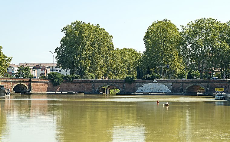
Photo: Archaeodontosaurus, CC BY-SA 3.0.
The Ponts Jumeaux is the point at which the Canal du Midi joins the Canal de Garonne and the River Garonne, via the Canal de Brienne. It was built in 1774 by Joseph-Marie de Saget, a civil engineer in the province of Languedoc in Toulouse.

Mur des palmarès
- Type: Work of art
- Category: tourism
- Location: Haute-Garonne, Occitanie, France, Europe
- View on OpenStreetMap
Latitude
43.62177° or 43° 37′ 18″ northLongitude
1.41397° or 1° 24′ 50″ eastOpen location code
8FM3JCC7+PHOpenStreetMap ID
node 8812166573OpenStreetMap feature
tourism=artwork
This page is based on OpenStreetMap, Wikidata, and Wikimedia Commons.
We’d love your help improving our open data sources. Thank you for contributing.
Satellite Map
Discover Mur des palmarès from above in high-definition satellite imagery.
Notable Places Nearby
Highlights include Place Charles Bimes and Stade Toulousain Padel.
Nearby Places
Explore places such as Boutique du Stade and La Brasserie du Stade.
Haute-Garonne: Must-Visit Destinations
Delve into Toulouse, Boutx, Tarn, and Roquesérière.
Curious Work Of Arts to Discover
Uncover intriguing work of arts from every corner of the globe.
About Mapcarta. Data © OpenStreetMap contributors and available under the Open Database License". Text is available under the CC BY-SA 4.0 license, except for photos, directions, and the map. Photo: Kulmalukko, CC BY-SA 3.0.