Baltschieder Hut
The Baltschieder Hut is a mountain hut of the Swiss Alpine Club, located north of Baltschieder in the canton of Valais. It lies at a height of 2,783 metres above sea level, at the end of the Baltschiedertal near the Bietschhorn.| Tap on a place to explore it |
Photo: Wikimedia, CC BY-SA 3.0.
Places of Interest Nearby
Highlights include Bietschhorn and Breithorn.
Bietschhorn
Peak
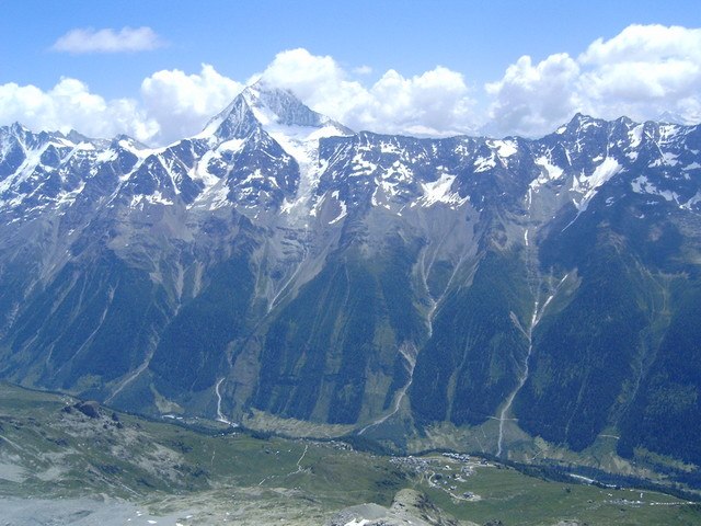
Photo: Telnet, CC BY-SA 3.0.
The Bietschhorn is a mountain in canton Wallis to the south of the Bernese Alps in Switzerland. The northeast and southern slopes of the mountain are part of the Jungfrau-Aletsch Protected Area listed as a UNESCO World Heritage Site that also includes the Jungfrau and the Aletsch Glacier. Bietschhorn is situated 3 km west of Baltschieder Hut.
Breithorn
Peak
 The Breithorn is a mountain of the Bernese Alps, located east of Blatten in the canton of Valais. It lies between the Bietschhorn and the Schinhorn, on the range separating the Lötschental from the main Rhone valley. Breithorn is situated 2½ km north of Baltschieder Hut.
Nesthorn
Peak

Photo: Cactus26, CC BY-SA 3.0.
The Nesthorn is a mountain in the Bernese Alps. It is located in the Swiss canton of Valais north of Brig. The mountain lies between the Oberaletsch Glacier on the north and east side and the Gredetschtal on the south side. Nesthorn is situated 3½ km northeast of Baltschieder Hut.
Places in the Area
Nearby places include Kühmad and Eisten.
Kühmad
Locality

Photo: Wikimedia, Public domain.
Kühmad is a locality, which is situated 5 km northwest of Baltschieder Hut.
Eisten
Hamlet

Photo: Wikimedia, Public domain.
Eisten is a hamlet, which is situated 6 km northwest of Baltschieder Hut.
Blatten
Village

Photo: Mo4jolo, CC BY-SA 2.5.
Blatten is a village, which is situated 6 km northwest of Baltschieder Hut.
Baltschieder Hut
- Type: Mountain hut
- Description: mountain hut
- Categories: tourism, accommodation, and building
- Location: Baltschieder, Visp District, Valais, Switzerland, Central Europe, Europe
- View on OpenStreetMap
Latitude
46.39498° or 46° 23′ 42″ northLongitude
7.8898° or 7° 53′ 23″ eastOperator
SAC - CASOpen location code
8FR99VVQ+XWOpenStreetMap ID
node 8857192925OpenStreetMap feature
tourism=alpine_hutWikidata ID
Q805816
This page is based on OpenStreetMap, Wikidata, Wikimedia Commons, and Wikipedia.
We’d love your help improving our open data sources. Thank you for contributing.
Satellite Map
Discover Baltschieder Hut from above in high-definition satellite imagery.
In Other Languages
“Baltschieder Hut” goes by many names.
- German: “Baltschiederklause”
Notable Places Nearby
Highlights include Jägihorn and Grüebhorn.
Nearby Places
Explore places such as Hohbitzu and Ehemaliges Bergwerk.
Valais: Must-Visit Destinations
Delve into Sion, Zermatt, Martigny, and Brig.
Curious Mountain Huts to Discover
Uncover intriguing mountain huts from every corner of the globe.
About Mapcarta. Data © OpenStreetMap contributors and available under the Open Database License". Text is available under the CC BY-SA 4.0 license, except for photos, directions, and the map. Description text is based on the Wikipedia page “Baltschieder Hut”. Photo: Wikimedia, CC BY-SA 3.0.