SIS Ingenieure
SIS Ingenieure is an office in Saarwellingen, Saarlouis, Saarland. SIS Ingenieure is situated nearby to the church Kapelle Arweiler, as well as near the grassland Hundesportverein Saarwellingen.| Tap on a place to explore it |
Places of Interest Nearby
Highlights include Rathausbrunnen and St. Johannes.
Rathausbrunnen
Fountain

Photo: FlocciNivis, CC BY-SA 4.0.
Rathausbrunnen is a fountain, which is situated 2 km east of SIS Ingenieure.
St. Johannes
Church
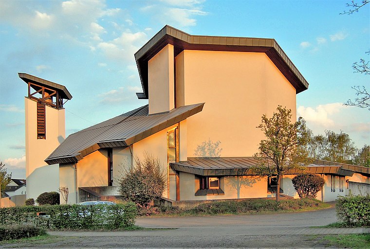
Photo: LoKiLeCh, CC BY-SA 3.0.
St. Johannes is a church, which is situated 2 km south of SIS Ingenieure.
Altes Schloss

Photo: Kolling, CC BY-SA 3.0.
Altes Schloss is a castle and museum in Dillingen, Saarland, Germany. The Old castle, like many castles, was originally a medieval castle, probably of the 14th century. Altes Schloss is situated 3½ km west of SIS Ingenieure.
Places in the Area
Nearby places include Saarwellingen and Nalbach.
Saarwellingen
Village
 Saarwellingen is a municipality in the district of Saarlouis in Saarland, Germany. As of 2022 it has a population of 13,302.
Nalbach
Village

Photo: Kolling, CC BY-SA 3.0.
Nalbach is a municipality in the district of Saarlouis in Saarland, Germany. It is situated approximately 8 km northeast of Saarlouis, and 20 km northwest of Saarbrücken.
Dillingen
Town

Photo: Kolling, CC BY-SA 3.0.
Dillingen is a town in the district of Saarlouis, in Saarland. It has about 20,000 inhabitants and is divided into the three districts Dillingen-city center, Pachten and Diefflen. Dillingen is situated 4 km west of SIS Ingenieure.
SIS Ingenieure
- Type: Office
- Location: Saarwellingen, Saarlouis, Saarland, Germany, Central Europe, Europe
- View on OpenStreetMap
Latitude
49.35693° or 49° 21′ 25″ northLongitude
6.78059° or 6° 46′ 50″ eastOpen location code
8FX89Q4J+Q6OpenStreetMap ID
node 8932418868OpenStreetMap feature
office=yes
This page is based on OpenStreetMap, Wikidata, and Wikimedia Commons.
We’d love your help improving our open data sources. Thank you for contributing.
Satellite Map
Discover SIS Ingenieure from above in high-definition satellite imagery.
Notable Places Nearby
Highlights include Kapelle Arweiler and Hundesportverein Saarwellingen.
Nearby Places
Explore places such as Alt & Kollegen and Mineral.
Saarland: Must-Visit Destinations
Delve into Saarbrücken, Saarlouis, Homburg, and Merzig.
Curious Offices to Discover
Uncover intriguing offices from every corner of the globe.
About Mapcarta. Data © OpenStreetMap contributors and available under the Open Database License". Text is available under the CC BY-SA 4.0 license, except for photos, directions, and the map. Photo: wolfgangstaudt, CC BY 2.0.