Dubai Dekor
Dubai Dekor is a convenience store in Cologne, Cologne Lowland, North Rhine-Westphalia which is located on Kalker Hauptstraße. Dubai Dekor is situated nearby to the community center Demokratie Space, as well as near the health club CO Yoga.| Tap on a place to explore it |
Places of Interest Nearby
Highlights include Kalk chapel and Kalk Kapelle station.
Kalk chapel
Church

Photo: Elya, CC BY-SA 4.0.
Kalk chapel is a church, which is situated 230 metres east of Dubai Dekor.
Kalk Kapelle station
Tram stop

Photo: Qualle, CC BY-SA 3.0.
Kalk Kapelle station is an underground station on the Cologne Stadtbahn lines 1 and 9, located in Cologne. The station lies at the intersection if the Kalker Hauptstraße and Kapellenstraße streets in the district of Kalk. Kalk Kapelle station is situated 170 metres east of Dubai Dekor.
Lanxess Arena
Stadium
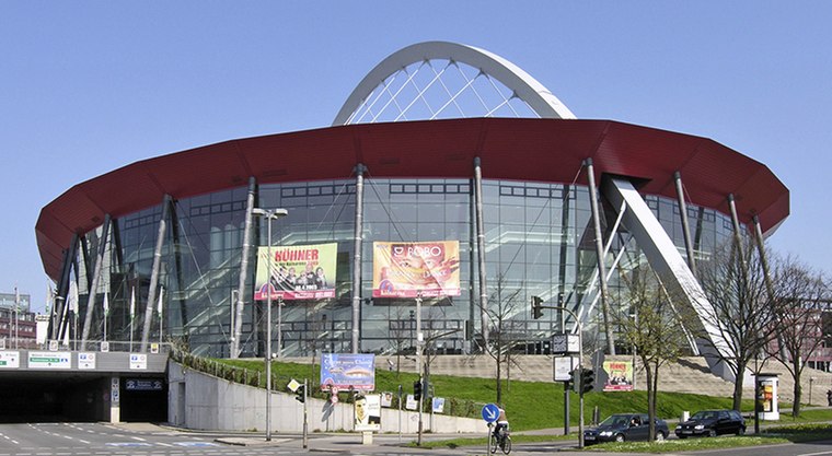
Photo: Hps-poll, CC BY-SA 3.0.
Lanxess Arena is an indoor arena, in Cologne, North Rhine-Westphalia, Germany. It is known as the 18,500-capacity home of the Kölner Haie and as one of Germany's major music venues. Lanxess Arena is situated 1½ km west of Dubai Dekor.
Places in the Area
Nearby places include Vingst and Deutz.

Deutz
Suburb

Photo: Tohma, CC BY-SA 4.0.
The Cologne borough of Deutz is a part of central Cologne, Germany, and was once an independent town known as Deutz am Rhein.
Agnesviertel
Neighborhood
 Agnesviertel is a neighborhood, which is situated 4 km northwest of Dubai Dekor.
Dubai Dekor
- Type: Convenience store
- Address: Kalker Hauptstraße 180, 51103
- Categories: shop and food
- Location: Cologne, Cologne District, Cologne Lowland, North Rhine-Westphalia, Germany, Central Europe, Europe
- View on OpenStreetMap
Latitude
50.93823° or 50° 56′ 18″ northLongitude
7.00581° or 7° 0′ 21″ eastOpen location code
9F29W2Q4+78OpenStreetMap ID
node 9055595721OpenStreetMap feature
shop=convenience
This page is based on OpenStreetMap, Wikidata, and Wikimedia Commons.
We’d love your help improving our open data sources. Thank you for contributing.
Satellite Map
Discover Dubai Dekor from above in high-definition satellite imagery.
Notable Places Nearby
Highlights include Demokratie Space and CO Yoga.
Nearby Places
Explore places such as Sun City and Kiwan 2 Barber Shop.
Cologne Lowland: Must-Visit Destinations
Delve into Bonn, Leverkusen, Siegburg, and Bad Honnef.
Curious Convenience Stores to Discover
Uncover intriguing convenience stores from every corner of the globe.
About Mapcarta. Data © OpenStreetMap contributors and available under the Open Database License". Text is available under the CC BY-SA 4.0 license, except for photos, directions, and the map. Photo: Ahgee, CC BY-SA 3.0.