Der Bergstraße-Rhein-Radweg
Der Bergstraße-Rhein-Radweg is in Ettlingen, Karlsruhe, Baden-Württemberg. Der Bergstraße-Rhein-Radweg is situated nearby to the cemetery Friedhof Ettlingen, as well as near the church Alexiuskapelle.| Tap on a place to explore it |
Places of Interest Nearby
Highlights include Bismarck Tower and Herz-Jesu-Kirche.
Bismarck Tower
Scenic viewpoint

Photo: Muck50, CC BY-SA 4.0.
Bismarck Tower is a scenic viewpoint, which is situated 1 km southeast of Der Bergstraße-Rhein-Radweg.
Herz-Jesu-Kirche
Church

Photo: Gerd Eichmann, CC BY-SA 4.0.
Herz-Jesu-Kirche is a church, which is situated 690 metres south of Der Bergstraße-Rhein-Radweg.
Ettlingen Palace
Public building
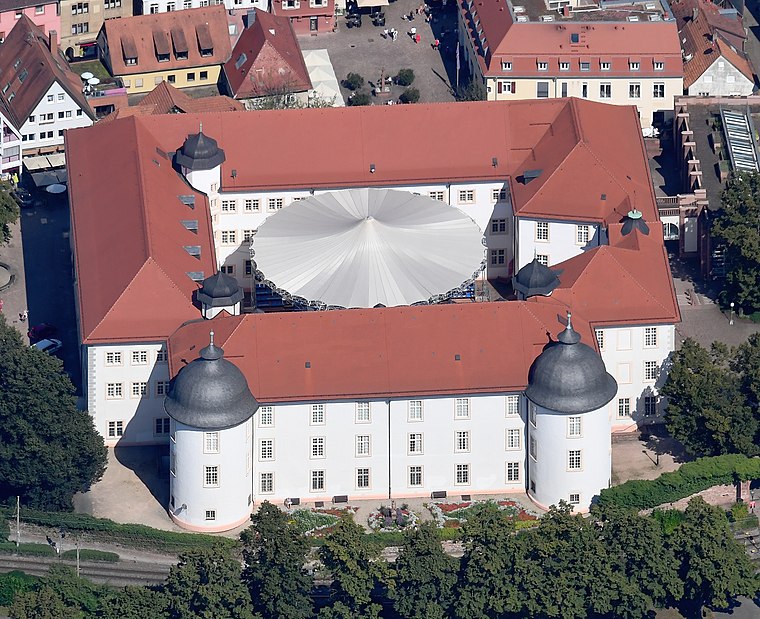
Photo: Carsten Steger, CC BY-SA 4.0.
Ettlingen Palace is a baroque palace in the centre of Ettlingen, a small city in Baden-Württemberg, Germany. Ettlingen Palace is situated 1¼ km southwest of Der Bergstraße-Rhein-Radweg.
Places in the Area
Nearby places include Spessart and Wolfartsweier.
Spessart
Village

Photo: Elwood j blues, CC BY-SA 3.0.
Spessart is a village, which is situated 4½ km south of Der Bergstraße-Rhein-Radweg.
Wolfartsweier
Suburb
Wolfartsweier is a village and a quarter of Karlsruhe, Baden-Württemberg, Germany. Its population is 3,068. It was first mentioned in 1261 AD under the name of "Wolvoldeswilere". Wolfartsweier is situated 4½ km northeast of Der Bergstraße-Rhein-Radweg.
Waldbronn
Town

Photo: Spacefrank, CC BY-SA 2.5.
Waldbronn is a municipality in the district of Karlsruhe, in Baden-Württemberg, Germany. It is situated in the northern Black Forest, 11 kilometres southeast of Karlsruhe. Waldbronn is situated 5 km southeast of Der Bergstraße-Rhein-Radweg.
Der Bergstraße-Rhein-Radweg
- Type: Map
- Categories: information and tourism
- Location: Ettlingen, Karlsruhe, Karlsruhe Region, Rhine-Neckar, Baden-Württemberg, Germany, Central Europe, Europe
- View on OpenStreetMap
Latitude
48.94927° or 48° 56′ 57″ northLongitude
8.4131° or 8° 24′ 47″ eastOpen location code
8FWCWCX7+P6OpenStreetMap ID
node 9095299645OpenStreetMap feature
tourism=information
This page is based on OpenStreetMap, Wikidata, and Wikimedia Commons.
We’d love your help improving our open data sources. Thank you for contributing.
Satellite Map
Discover Der Bergstraße-Rhein-Radweg from above in high-definition satellite imagery.
Notable Places Nearby
Highlights include Friedhof Ettlingen and Alexiuskapelle.
Nearby Places
Explore places such as Alte Aussegnungshalle and Ettlingen.
Rhine-Neckar: Must-Visit Destinations
Delve into Heidelberg, Karlsruhe, Mannheim, and Heilbronn.
Curious Places to Discover
Uncover intriguing places from every corner of the globe.
About Mapcarta. Data © OpenStreetMap contributors and available under the Open Database License". Text is available under the CC BY-SA 4.0 license, except for photos, directions, and the map. Photo: Martin-D, CC BY-SA 2.5.