うめきたセラー
うめきたセラー is a shopping center in Kita-ku, Osaka, Osaka. うめきたセラー is situated nearby to うめきた広場, as well as near the garden 南館テラスガーデン.| Tap on a place to explore it |
Places of Interest Nearby
Highlights include Ōsaka Station and LUCUA 1100.
Ōsaka Station
Railway station
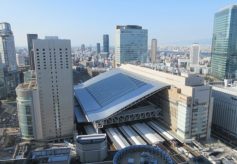
Photo: KishujiRapid, CC BY-SA 4.0.
Ōsaka Station is a major railway station in the Umeda district of Kita-ku, Osaka, Japan, operated by West Japan Railway Company. It forms as one of the city's main railway terminals to the north, the other being Shin-Ōsaka. Ōsaka Station is situated 180 metres southeast of うめきたセラー.
LUCUA 1100
Shopping center

Photo: Tokumeigakarinoaoshima, CC0.
LUCUA 1100 is a shopping center, which is situated 110 metres south of うめきたセラー.
Osaka-Umeda
Railway station

Photo: Tokumeigakarinoaoshima, CC BY-SA 4.0.
Osaka-Umeda is a railway station, which is situated 340 metres southeast of うめきたセラー.
Places in the Area
Nearby places include Doyamacho and Kita.
Doyamacho
Neighborhood

Photo: Path-x21, CC BY-SA 4.0.
Dōyamachō is a district in the Umeda area of Osaka, Japan. It is close to the JR Osaka and Umeda Station, many restaurants, bars, izakaya, karaoke, massage parlors, host clubs, hotels, and shops concentrate in the area.
Kita

Photo: Martin Abegglen, CC BY-SA 2.0.
The Kita is the newest centre of Osaka city. The area around Umeda station, where major terminals for the Osaka subway, Japan Rail, Hankyu and Hanshin railways can be found, boasts department stores, buildings full of fashionable shops and various attractions.
Yodogawa-ku
Suburb

Photo: Wikimedia, CC BY-SA 3.0.
Yodogawa is one of 24 wards of Osaka, Japan. It is located in the north of the city.
うめきたセラー
- Type: Shopping center
- Category: shop
- Location: Kita-ku, Osaka, Osaka, Kansai, Japan, East Asia, Asia
- View on OpenStreetMap
Latitude
34.70367° or 34° 42′ 13″ northLongitude
135.49468° or 135° 29′ 41″ eastOpen location code
8Q6QPF3V+FVOpenStreetMap ID
node 9320739974OpenStreetMap feature
shop=mall
This page is based on OpenStreetMap, Wikidata, and Wikimedia Commons.
We’d love your help improving our open data sources. Thank you for contributing.
Satellite Map
Discover うめきたセラー from above in high-definition satellite imagery.
Notable Places Nearby
Highlights include 南館テラスガーデン and うめきた広場.
Nearby Places
Explore places such as Mont-bell and GARB MONAQUE.
Osaka: Must-Visit Destinations
Delve into Toyonaka, Osaka castle, Bay Area, and Minami.
Curious Shopping Centers to Discover
Uncover intriguing shopping centers from every corner of the globe.
About Mapcarta. Data © OpenStreetMap contributors and available under the Open Database License". Text is available under the CC BY-SA 4.0 license, except for photos, directions, and the map. Photo: Martin Abegglen, CC BY-SA 2.0.