Hub Hall Heights
Hub Hall Heights is a neighborhood in Lancaster, Nebraska. Hub Hall Heights is situated nearby to the neighborhood Oak Hills, as well as near Ashley Heights.| Tap on a place to explore it |
Places in the Area
Nearby places include Emerald and Haymarket District.
Emerald
Hamlet

Photo: Dysalot, CC BY-SA 4.0.
Emerald is an unincorporated community in Lancaster County, Nebraska, United States. The population was 45 at the 2020 census. Emerald is situated 3 miles southwest of Hub Hall Heights.
Haymarket District
Suburb
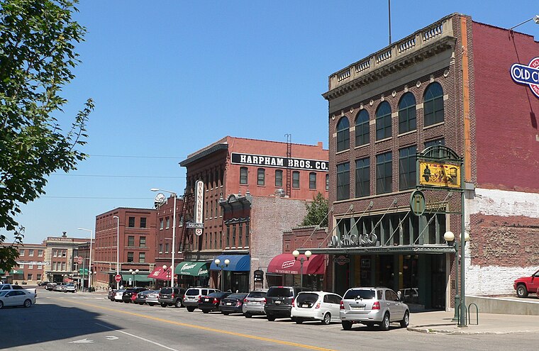
Photo: Ammodramus, CC0.
Haymarket District is a neighborhood and historic district of Downtown Lincoln, Nebraska, United States. The district was created in 1874 and was originally known as Haymarket Square. Haymarket District is situated 4 miles east of Hub Hall Heights.
Lincoln

Photo: Collinulness, CC BY-SA 3.0.
Lincoln is the capital and second largest city of Nebraska, U.S. As the state capital, it offers several historical sites, as well as museums, art galleries, and other cultural venues.
Hub Hall Heights
- Type: Neighborhood
- Category: locality
- Location: Lancaster, Nebraska, Great Plains, United States, North America
- View on OpenStreetMap
Latitude
40.8315° or 40° 49′ 53″ northLongitude
-96.78264° or 96° 46′ 58″ westOpen location code
86G5R6J8+HWOpenStreetMap ID
node 9392675884OpenStreetMap feature
place=neighbourhood
This page is based on OpenStreetMap, Wikidata, and Wikimedia Commons.
We’d love your help improving our open data sources. Thank you for contributing.
Satellite Map
Discover Hub Hall Heights from above in high-definition satellite imagery.
Localities in the Area
Explore places such as Oak Hills and Ashley Heights.
Notable Places Nearby
Highlights include Union Bank and Trust Stadium and Complete Fitness.
Nebraska: Must-Visit Destinations
Delve into Lincoln, Omaha, Grand Island, and Kearney.
Curious Neighborhoods to Discover
Uncover intriguing neighborhoods from every corner of the globe.
About Mapcarta. Data © OpenStreetMap contributors and available under the Open Database License". Text is available under the CC BY-SA 4.0 license, except for photos, directions, and the map. Photo: Kahvc7, CC0.