Kani Kiosk
Kani Kiosk is a kiosk in Munich, Upper Bavaria, Bavaria which is located on Leuchtenbergring. Kani Kiosk is situated nearby to the health club Fitness First, as well as near the quarter Steinhausen.| Tap on a place to explore it |
- Type: Kiosk
- Address: Leuchtenbergring 5, München
- Wheelchair access: yes
Places of Interest Nearby
Highlights include Das Einstein and Munich Leuchtenbergring station.
Das Einstein
Shopping center

Photo: Rufus46, CC BY-SA 3.0.
Das Einstein is a shopping center, which is situated 130 metres southwest of Kani Kiosk.
Munich Leuchtenbergring station
Railway station

Photo: Flummi-2011, CC BY-SA 3.0.
Munich Leuchtenbergring is a railway station on the Munich–Salzburg line in the Bogenhausen quarter of Munich, Germany. It is an elevated station above the Leuchtenbergring, part of Munich's Mittlerer Ring road system. Munich Leuchtenbergring station is situated 320 metres south of Kani Kiosk.
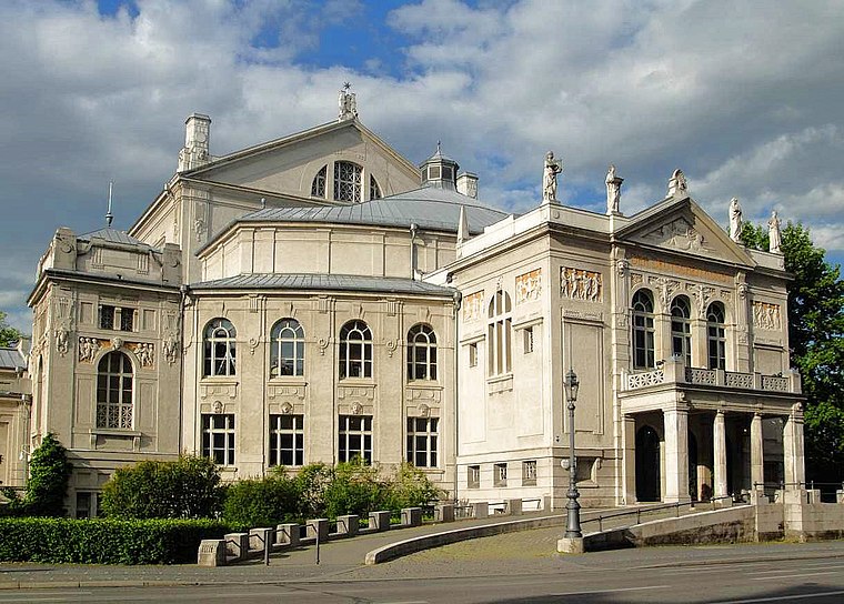
Prinzregententheater
Theater building

Photo: Wikimedia, CC BY-SA 3.0.
The Prinzregententheater, or, as it was called in its first decades, the Prinz-Regenten-Theater, in English the Prince Regent Theatre, is a concert hall and opera house on Prinzregentenplatz in the Bavarian capital of Munich, Germany. Prinzregententheater is situated 720 metres west of Kani Kiosk.
Places in the Area
Nearby places include Steinhausen and Parkstadt Bogenhausen.


Kani Kiosk
- Category: shop
- Location: Munich, Upper Bavaria, Bavaria, Germany, Central Europe, Europe
- View on OpenStreetMap
Latitude
48.1371° or 48° 8′ 14″ northLongitude
11.61515° or 11° 36′ 55″ eastOpen location code
8FWH4JP8+R3OpenStreetMap ID
node 9425101745OpenStreetMap feature
shop=kioskOpenStreetMap attribute
wheelchair=yes
This page is based on OpenStreetMap, Wikidata, and Wikimedia Commons.
We’d love your help improving our open data sources. Thank you for contributing.
Satellite Map
Discover Kani Kiosk from above in high-definition satellite imagery.
Notable Places Nearby
Highlights include Fitness First and St. Gabriel.
Nearby Places
Explore places such as Kani Kiosk and Döner & More.
Munich: Must-Visit Destinations
Delve into North Munich, Altstadt, Haidhausen, and Ludwigsvorstadt-Isarvorstadt.
Curious Kiosks to Discover
Uncover intriguing kiosks from every corner of the globe.
About Mapcarta. Data © OpenStreetMap contributors and available under the Open Database License". Text is available under the CC BY-SA 4.0 license, except for photos, directions, and the map. Photo: Heav84, CC BY-SA 3.0.