Unterteufenbach Ort
Unterteufenbach Ort is a bus stop in Sankt Florian am Inn, Schärding District, Upper Austria. Unterteufenbach Ort is situated nearby to the fire station Feuerwehrhaus Allerding, as well as near the aerodrome Schärding-Suben Airport.| Tap on a place to explore it |
Places of Interest Nearby
Highlights include Filialkirche hl. Laurentius, Wagholming and Schärding-Suben Airport.
Filialkirche hl. Laurentius, Wagholming
Church

Photo: Aberpram, CC BY-SA 3.0.
Filialkirche hl. Laurentius, Wagholming is a church, which is situated 2 km northeast of Unterteufenbach Ort.
Schärding-Suben Airport
Aerodrome
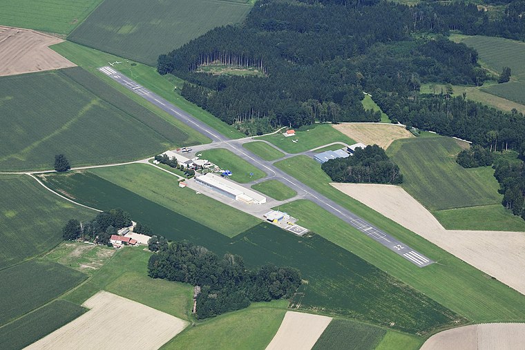
Photo: Carsten Steger, CC BY-SA 4.0.
Schärding-Suben Airport is a private use airport located 7 kilometres south of Schärding, Upper Austria, Austria. Schärding-Suben Airport is situated 3 km west of Unterteufenbach Ort.
Places in the Area
Nearby places include Unterfucking and Oberfucking.
Unterfucking
Hamlet
Unterfucking is a populated place that is part of Sankt Marienkirchen bei Schärding, Schärding, Upper Austria, Austria. Unterfucking has often been included in lists of places with unusual names, due to the fact that part of its name bears a similarity to the English-language expletive "fuck". Unterfucking is situated 3 km southwest of Unterteufenbach Ort.
Oberfucking
Hamlet

Photo: Croq, CC BY-SA 3.0.
Oberfucking is a populated place in Upper Austria, Austria. It is a part of the town St. Marienkirchen bei Schärding in district Schärding, near the border to Germany. Oberfucking is situated 3½ km south of Unterteufenbach Ort.
Mittich
Village

Photo: Konrad Lackerbeck, CC BY 3.0.
Mittich is a village, which is situated 8 km northwest of Unterteufenbach Ort.
Unterteufenbach Ort
- Type: Bus stop
- Wheelchair access: yes
- Category: transportation
- Location: Sankt Florian am Inn, Schärding District, Upper Austria, Austria, Central Europe, Europe
- View on OpenStreetMap
Latitude
48.40357° or 48° 24′ 13″ northLongitude
13.49133° or 13° 29′ 29″ eastOpen location code
8FWMCF3R+CGOpenStreetMap ID
node 9458633165OpenStreetMap feature
highway=bus_stopOpenStreetMap feature
public_transport=platformOpenStreetMap attribute
wheelchair=yes
This page is based on OpenStreetMap, Wikidata, and Wikimedia Commons.
We’d love your help improving our open data sources. Thank you for contributing.
Satellite Map
Discover Unterteufenbach Ort from above in high-definition satellite imagery.
Notable Places Nearby
Highlights include Feuerwehrhaus Allerding and FF Laufenbach.
Nearby Places
Explore places such as Unterteufenbach Ort and Teufenbach.
Upper Austria: Must-Visit Destinations
Delve into Linz, Hallstatt, Wels, and Steyr.
Curious Bus Stops to Discover
Uncover intriguing bus stops from every corner of the globe.
About Mapcarta. Data © OpenStreetMap contributors and available under the Open Database License". Text is available under the CC BY-SA 4.0 license, except for photos, directions, and the map. Photo: Traveler100, CC BY-SA 3.0.