Monroe Street Farmers Market
Monroe Street Farmers Market is a marketplace in Washington, D.C., Mid-Atlantic which is located on Monroe Street Northeast. Monroe Street Farmers Market is situated nearby to the art gallery Terratorie Maps + Goods, as well as near the arts center Only Make Believe.| Tap on a place to explore it |
- Opening hours: Saturday 10:00 AM—1:00 PM
- Type: Marketplace
- Address: 716 Monroe Street Northeast, Washington, DC 20017
Places of Interest Nearby
Highlights include Brookland–CUA station and Basilica of the National Shrine of the Immaculate Conception.
Brookland–CUA station
Metro station

Photo: SchuminWeb, CC BY-SA 2.5.
Brookland–CUA station is a Washington Metro station in Washington, D.C., on the Red Line. Service began on February 6, 1978. The station serves the Brookland neighborhood and the Catholic University of America.
Basilica of the National Shrine of the Immaculate Conception
Church

Photo: AgnosticPreachersKid, CC BY-SA 3.0.
The Basilica of the National Shrine of the Immaculate Conception is a Catholic minor basilica and national shrine in Washington D.C. It is the largest Catholic church building in North America and is also the tallest habitable building in Washington, D.C. Basilica of the National Shrine of the Immaculate Conception is situated 1,600 feet west of Monroe Street Farmers Market.
Maloney Hall
University building
Maloney Hall is the home of the Busch School of Business and Economics at the Catholic University of America. It is located in the southeast corner of Catholic University’s main campus, near the Brookland–CUA station.
Places in the Area
Nearby places include Brookland and Edgewood.
Brookland
Suburb
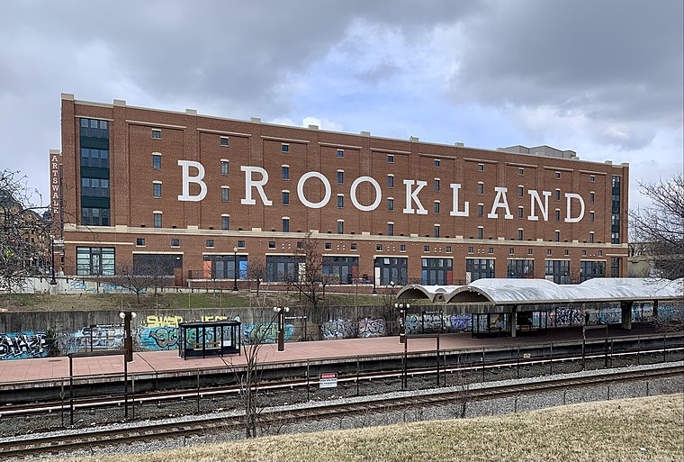
Photo: APK, CC BY-SA 4.0.
Brookland, Petworth, and Takoma are three relatively quiet neighborhoods east of Rock Creek Park. Following the "White Flight" after desegregation and the 1968 riots, these neighborhoods were left underpopulated, overwhelmingly African-American, and much less wealthy than the Upper Northwest, just across Rock Creek Park.
Edgewood
Neighborhood
 Edgewood is a neighborhood located in Ward 5 of Northeast Washington, D.C. Edgewood is bounded by Michigan Avenue NE to the north, Rhode Island Avenue NE to the south, North Capitol Street to the west, and the Washington Metro's Red Line to the east.
Michigan Park
Neighborhood
Michigan Park is a neighborhood in Ward 5 of Northeast Washington, D.C. in the Upper Northeast area element. The boundaries of Michigan Park and North Michigan Park neighborhoods are contested due to the history of racial disparity between the two, but…
Monroe Street Farmers Market
Latitude
38.93326° or 38° 55′ 60″ northLongitude
-76.99521° or 76° 59′ 43″ westOperator
FRESHFARM MarketsOpen location code
87C5W2M3+8WOpenStreetMap ID
node 9483455588OpenStreetMap feature
amenity=marketplace
This page is based on OpenStreetMap, Wikidata, and Wikimedia Commons.
We’d love your help improving our open data sources. Thank you for contributing.
Satellite Map
Discover Monroe Street Farmers Market from above in high-definition satellite imagery.
Notable Places Nearby
Highlights include Terratorie Maps + Goods and Only Make Believe.
Nearby Places
Explore places such as Transformation Junkies and Tolbert & Bing Studio.
Washington, D.C.: Must-Visit Destinations
Delve into West End, East End, Georgetown, and Shaw.
Curious Marketplaces to Discover
Uncover intriguing marketplaces from every corner of the globe.
About Mapcarta. Data © OpenStreetMap contributors and available under the Open Database License". Text is available under the CC BY-SA 4.0 license, except for photos, directions, and the map. Photo: Peterfitzgerald, CC BY-SA 3.0.