Frostkellersweg
Frostkellersweg is a locality in Eschweiler, Aachen, North Rhine-Westphalia. Frostkellersweg is situated nearby to the locality Lohner Höhe, as well as near Am Eselsacker.| Tap on a place to explore it |
Places of Interest
Highlights include Gedächtniskapelle Lohn and Saint Cornelius Church.
Gedächtniskapelle Lohn
Church

Photo: EveryPicture, CC BY-SA 3.0.
Gedächtniskapelle Lohn is a church.

Weisweiler power plant
Power station
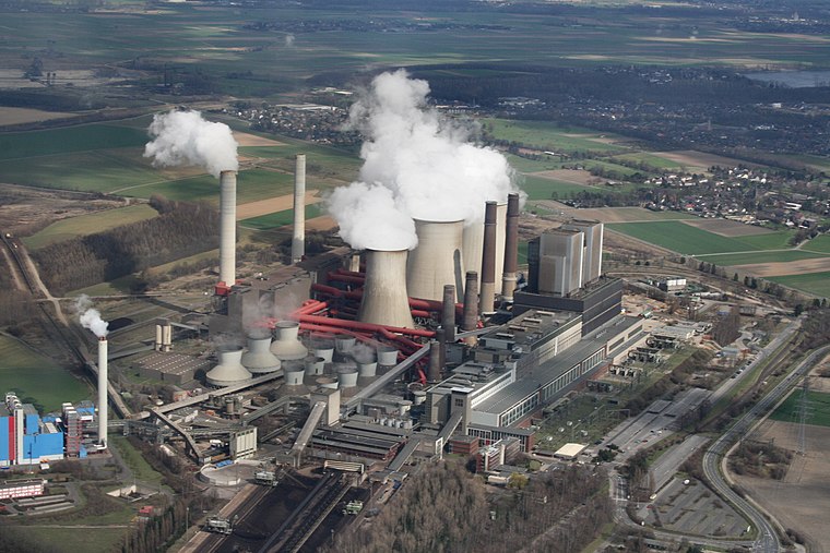
Photo: Frankherz, Public domain.
Weisweiler power plant is a power station, which is situated 2½ km south of Frostkellersweg.
Places in the Area
Nearby places include Lamersdorf (Inden, Germany) and Frenz.
Lamersdorf (Inden, Germany)
Village

Photo: Wikimedia, Public domain.
Lamersdorf (Inden, Germany) is a village.
Frenz
Village

Photo: Papa1234, Public domain.
Frenz is a village, which is situated 3 km south of Frostkellersweg.
Lucherberg
Village

Photo: Wikimedia, CC BY-SA 4.0.
Lucherberg is a village, which is situated 3½ km southeast of Frostkellersweg.
Frostkellersweg
- Type: Locality
- Location: Eschweiler, Aachen, Cologne District, North Rhine-Westphalia, Germany, Central Europe, Europe
- View on OpenStreetMap
Latitude
50.86226° or 50° 51′ 44″ northLongitude
6.329° or 6° 19′ 44″ eastOpen location code
9F28V86H+WJOpenStreetMap ID
node 9673756564OpenStreetMap feature
place=locality
This page is based on OpenStreetMap, Wikidata, and Wikimedia Commons.
We’d love your help improving our open data sources. Thank you for contributing.
Satellite Map
Discover Frostkellersweg from above in high-definition satellite imagery.
Localities in the Area
Explore places such as Lohner Höhe and Am Eselsacker.
Notable Places Nearby
Highlights include RWE Werkfeuerwehr and Motocross-Anlage MSC-Grenzland 1982 e.V..
North Rhine-Westphalia: Must-Visit Destinations
Delve into Cologne, Düsseldorf, Bonn, and Dortmund.
Curious Localities to Discover
Uncover intriguing localities from every corner of the globe.
About Mapcarta. Data © OpenStreetMap contributors and available under the Open Database License". Text is available under the CC BY-SA 4.0 license, except for photos, directions, and the map. Photo: Daniel Schwen, CC BY-SA 2.5.