Connecticut Office of Emergency Management
Connecticut Office of Emergency Management is a government office in Town of Hartford, Capitol Planning Region, Connecticut which is located on Sigourney Street. Connecticut Office of Emergency Management is situated nearby to the bus station Sigourney Street station, as well as near Pope Park North.| Tap on a place to explore it |
Places of Interest Nearby
Highlights include Sigourney Street station and Mark Twain House Museum.
Sigourney Street station
Bus station

Photo: Pi.1415926535, CC BY-SA 3.0.
Sigourney Street is a bus rapid transit station on the CTfastrak line, located near the intersection of Sigourney Street and Hawthorn Street in Hartford, Connecticut, near Aetna corporate headquarters. Sigourney Street station is situated 620 feet north of Connecticut Office of Emergency Management.
Mark Twain House Museum
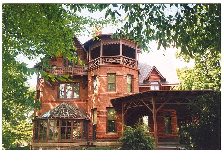
Photo: Makemake, CC BY-SA 3.0.
The Mark Twain House and Museum in Hartford, Connecticut, was the home of Samuel Langhorne Clemens and his family from 1874 to 1891. The Clemens family had it designed by Edward Tuckerman Potter and built in the America High Gothic style. Mark Twain House Museum is situated 2,400 feet northwest of Connecticut Office of Emergency Management.
Connecticut State Capitol
Town hall
 The Connecticut State Capitol is located north of Capitol Avenue and south of Bushnell Park in Hartford, the capital of Connecticut. The building houses the Connecticut General Assembly; the upper house, the State Senate, and lower house, the House of Representatives, as well as the office of the Governor of the State of Connecticut. Connecticut State Capitol is situated 3,400 feet east of Connecticut Office of Emergency Management.
Places in the Area
Nearby places include Imlay and Laurel Streets District and Hartford.
Imlay and Laurel Streets District
Neighborhood

Photo: Magicpiano, CC BY-SA 4.0.
The Imlay and Laurel Streets District is a residential historic district on portions of Imlay, Laurel, Hawthorn and Sigourney Streets in Hartford, Connecticut.
Hartford

Photo: Ricky Aponte, CC BY 2.0.
Hartford is the capital of the state of Connecticut in the United States of America. It is home to the country's oldest public art museum, and the Mark Twain House, in which the author wrote his most famous works and raised his family.
Frog Hollow
Neighborhood
Frog Hollow is one of the neighborhoods of Hartford, Connecticut. It is a predominantly residential area, bounded on the north by Capitol Avenue, the east by Lafayette Street, the south by Madison and Hamilton Streets, and on the west by Interstate 84.
Connecticut Office of Emergency Management
- Type: Government office
- Address: 25 Sigourney Street, Hartford, CT 06106
- Categories: office and government building
- Location: Town of Hartford, Capitol Planning Region, Connecticut, New England, United States, North America
- View on OpenStreetMap
Latitude
41.76274° or 41° 45′ 46″ northLongitude
-72.69463° or 72° 41′ 41″ westOpen location code
87H9Q874+34OpenStreetMap ID
node 9918230395OpenStreetMap feature
office=government
This page is based on OpenStreetMap, Wikidata, and Wikimedia Commons.
We’d love your help improving our open data sources. Thank you for contributing.
Satellite Map
Discover Connecticut Office of Emergency Management from above in high-definition satellite imagery.
Notable Places Nearby
Highlights include Sigourney Street Station and Pope Park North.
Nearby Places
Explore places such as Pope Park Pump Station and Fire-N-Spice Vegan Restaurant & Sports Cafe.
Connecticut: Must-Visit Destinations
Delve into Hartford, New Haven, Bridgeport, and Stamford.
Curious Government Offices to Discover
Uncover intriguing government offices from every corner of the globe.
About Mapcarta. Data © OpenStreetMap contributors and available under the Open Database License". Text is available under the CC BY-SA 4.0 license, except for photos, directions, and the map. Photo: Wikimedia, CC0.