Stefra’s Snack Bar
Stefra’s Snack Bar is a fast food restaurant in Old Toronto, Toronto, Ontario. Stefra’s Snack Bar is situated nearby to Westin Harbour Castle Hotel, as well as near the memorial Statue of Jack Layton.| Tap on a place to explore it |
Places of Interest Nearby
Highlights include Yonge-Dundas and Scotiabank Arena.
Yonge-Dundas

Photo: Benson Kua, CC BY-SA 2.0.
Yonge-Dundas is the very heart of downtown Toronto—in more ways than one. After all, the major arterials of Yonge Street and Dundas St meet here, and the resulting intersection may be the city's busiest.
Scotiabank Arena
Stadium
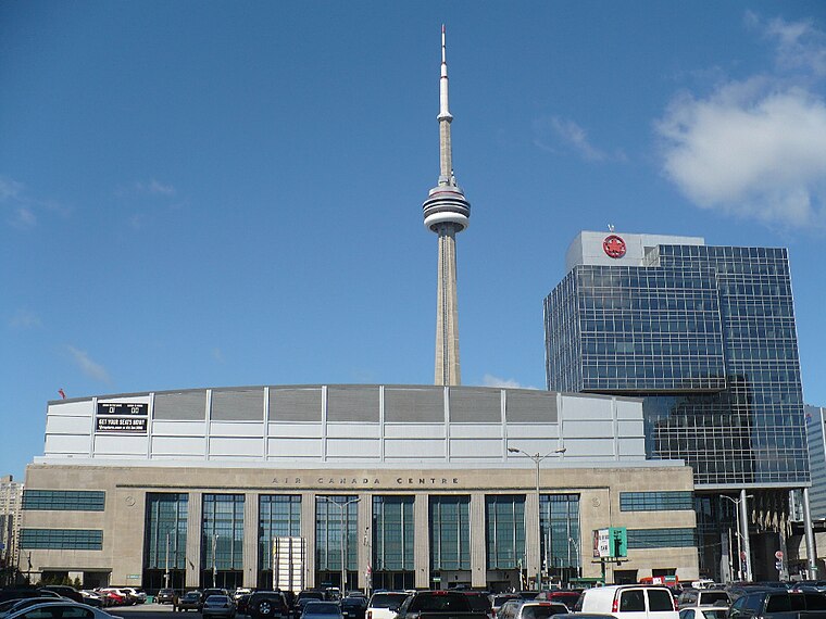
Photo: Secondarywaltz, Public domain.
Scotiabank Arena, formerly known as Air Canada Centre, is a multi-purposed arena located on Bay Street in downtown Toronto, Ontario, Canada. It is the home of the Toronto Raptors of the National Basketball Association and the Toronto Maple Leafs of the National Hockey League. Scotiabank Arena is situated 450 metres northwest of Stefra’s Snack Bar.
CN Tower

Photo: Taxiarchos228, CC BY-SA 3.0.
The CN Tower is a 553.3 m-high communications and observation tower in Toronto, Ontario, Canada. Completed in 1976, it is located in downtown Toronto, built on the former Railway Lands. CN Tower is situated 1 km west of Stefra’s Snack Bar.
Places in the Area
Nearby places include South Core and Harbourfront.
South Core
Neighborhood

Photo: Wikiworld2, CC BY-SA 3.0.
South Core is a neighbourhood located in downtown Toronto, Ontario, Canada. The South Core occupies the eastern portions of the Railway Lands. The remodeling and restoration of Union Station and the construction of a new wave of business and condominium towers is central to this area's forecast growth.
Harbourfront

Photo: Traveler100, CC BY-SA 3.0.
The Harbourfront neighbourhood in Toronto encompasses the area from the lakeshore corridor railway line in the north down to Lake Ontario in the south and from Exhibition Place in the west to Parliament Street in the east.
East Bayfront
Neighborhood

Photo: George Socka, CC BY 2.0.
East Bayfront, or the East Bayfront Precinct, is an emerging neighbourhood in Toronto, Ontario, Canada. It is currently undergoing a transformation from industrial use to mixed-use as part of Waterfront Toronto's plans to create a residential and commercial district urban core near the lake.
Stefra’s Snack Bar
- Type: Fast food restaurant
- Cuisine: Caribbean
- Categories: food and restaurant
- Location: Old Toronto, Toronto, Greater Toronto Area, Ontario, Canada, North America
- View on OpenStreetMap
Latitude
43.64046° or 43° 38′ 26″ northLongitude
-79.37527° or 79° 22′ 31″ westOpen location code
87M2JJRF+5VOpenStreetMap ID
node 9920786710OpenStreetMap feature
amenity=fast_foodOpenStreetMap attribute
cuisine=caribbean
This page is based on OpenStreetMap, Wikidata, and Wikimedia Commons.
We’d love your help improving our open data sources. Thank you for contributing.
Satellite Map
Discover Stefra’s Snack Bar from above in high-definition satellite imagery.
Notable Places Nearby
Highlights include Westin Harbour Castle Hotel and Statue of Jack Layton.
Nearby Places
Explore places such as Jack Layton Ferry Terminal and Jack Layton Ferry Terminal.
Toronto: Must-Visit Destinations
Delve into Yorkville and the Annex, Midtown, East End, and Downtown East.
Curious Fast Food Restaurants to Discover
Uncover intriguing fast food restaurants from every corner of the globe.
About Mapcarta. Data © OpenStreetMap contributors and available under the Open Database License". Text is available under the CC BY-SA 4.0 license, except for photos, directions, and the map. Photo: S23678, CC BY-SA 3.0.