Karl-Markus Herz
Karl-Markus Herz is a memorial in Braunschweig, Brunswick, Lower Saxony. Karl-Markus Herz is situated nearby to the playground Spielplatz Görgesstraße, as well as near the cemetery Petrifriedhof.| Tap on a place to explore it |
Places of Interest Nearby
Highlights include Weißes Ross and Dr. von Morgenstern Schulen.
Weißes Ross
Shopping center

Photo: Wikimedia, Public domain.
Weißes Ross is a shopping center, which is situated 510 metres north of Karl-Markus Herz.
Dr. von Morgenstern Schulen
School

Photo: Rothenbaum, CC BY-SA 3.0.
Dr. von Morgenstern Schulen is a school, which is situated 360 metres southeast of Karl-Markus Herz.
Brunswick Cathedral
Church
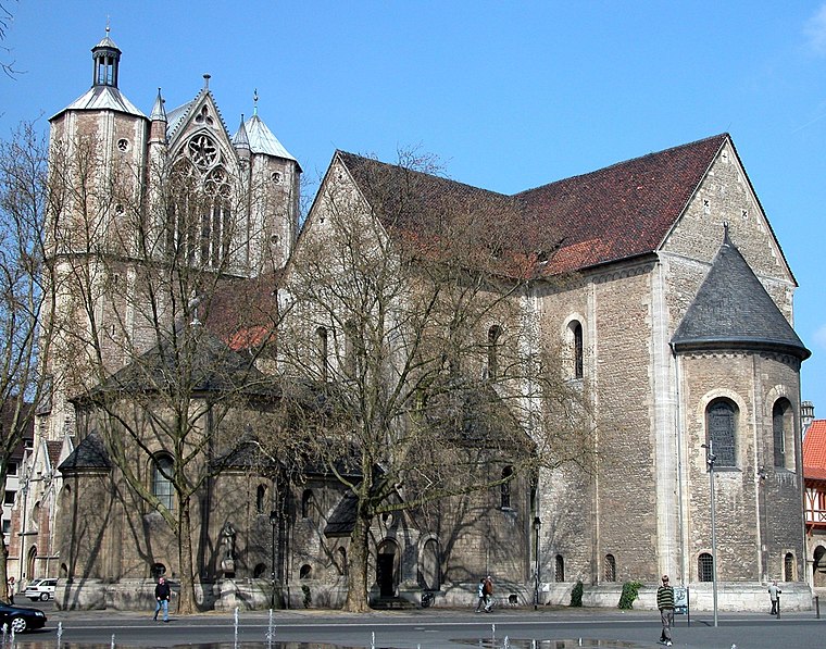
Photo: Brunswyk, Public domain.
Brunswick Cathedral is a large Lutheran church in the City of Braunschweig, Germany. The church is termed Dom, in German a synecdoche - pars pro toto - used for cathedrals and collegiate churches alike, and much like the Italian duomo. Brunswick Cathedral is situated 1½ km east of Karl-Markus Herz.
Places in the Area
Nearby places include Magniviertel and Östliches Ringgebiet.

Östliches Ringgebiet
Suburb

Photo: Brunswyk, CC BY-SA 3.0 de.
The Östliches Ringgebiet is a Stadtbezirk in the eastern part of Braunschweig, Germany. With a population of 26,559 it is the city's second most populous district. Östliches Ringgebiet is situated 2½ km east of Karl-Markus Herz.
Timmerlah
Village

Photo: Redonebird, CC BY-SA 3.0 de.
Timmerlah is a village, which is situated 5 km southwest of Karl-Markus Herz.
Karl-Markus Herz
- Type: Memorial
- Inscription: “Hier wohnte Karl-Markus Herz Jg. 1914 ‘Schutzhaft’ 1938 Sachsenhausen 1940 Neuengamme deportiert 1943 Auschwitz ermordet 27.4.1943”
- Category: historic site
- Location: Braunschweig, Brunswick, Brunswick Land, Lower Saxony, Germany, Central Europe, Europe
- View on OpenStreetMap
Latitude
52.2685° or 52° 16′ 7″ northLongitude
10.50408° or 10° 30′ 15″ eastOpen location code
9F4G7G93+CJOpenStreetMap ID
node 9983769666OpenStreetMap feature
historic=memorial
This page is based on OpenStreetMap, Wikidata, and Wikimedia Commons.
We’d love your help improving our open data sources. Thank you for contributing.
Satellite Map
Discover Karl-Markus Herz from above in high-definition satellite imagery.
Notable Places Nearby
Highlights include Spielplatz Görgesstraße and Petrifriedhof.
Nearby Places
Explore places such as Lieselotte Drung geb. Herz and Horst-Günther Herz.
Brunswick Land: Must-Visit Destinations
Delve into Wolfsburg, Salzgitter, Wolfenbüttel, and Helmstedt.
Curious Memorials to Discover
Uncover intriguing memorials from every corner of the globe.
About Mapcarta. Data © OpenStreetMap contributors and available under the Open Database License". Text is available under the CC BY-SA 4.0 license, except for photos, directions, and the map. Photo: Captaingrog, CC BY-SA 2.5.