Entertainment and Financial Districts
The Entertainment and Financial Districts, along with Yonge-Dundas to the north, form the heart of Toronto's downtown. By day, the suits and powerbrokers of the Financial District drive the city's economy from their glass and steel towers.| Tap on a place to explore it |
Photo: SimonP, CC BY-SA 3.0.
Photo: Taxiarchos228, CC BY-SA 3.0.
- Type: Neighborhood
- Description: neighbourhood in downtown Toronto, Canada
- Also known as: “Entertainment District”, “Entertainment District Toronto”, “Entertainment District, Toronto”, and “Toronto Entertainment District”
Places of Interest
Highlights include Yonge-Dundas and CN Tower.
Yonge-Dundas

Photo: Benson Kua, CC BY-SA 2.0.
Yonge-Dundas is the very heart of downtown Toronto—in more ways than one. After all, the major arterials of Yonge Street and Dundas St meet here, and the resulting intersection may be the city's busiest.
CN Tower

Photo: Taxiarchos228, CC BY-SA 3.0.
The CN Tower is a 553.3 m-high communications and observation tower in Toronto, Ontario, Canada. Completed in 1976, it is located in downtown Toronto, built on the former Railway Lands.
Scotiabank Arena
Stadium
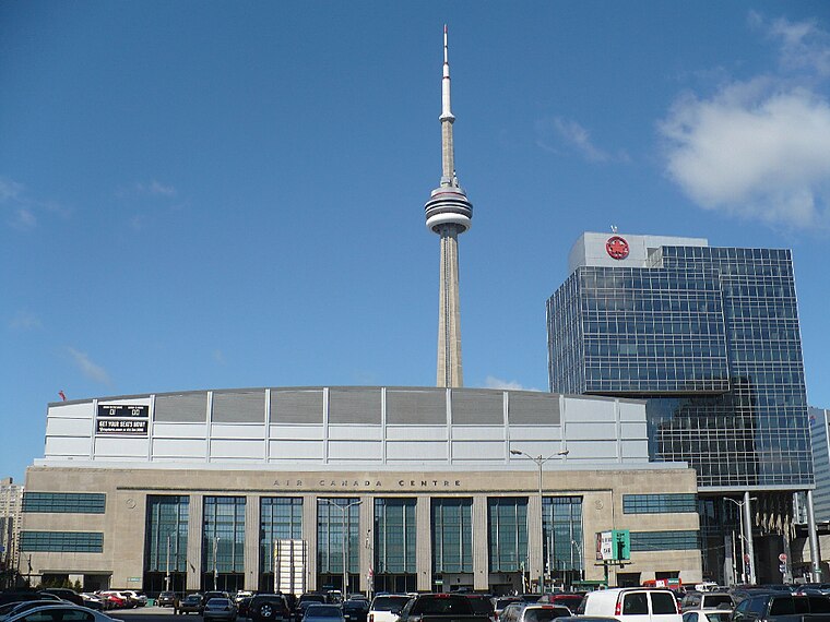
Photo: Secondarywaltz, Public domain.
Scotiabank Arena, formerly known as Air Canada Centre, is a multi-purposed arena located on Bay Street in downtown Toronto, Ontario, Canada. It is the home of the Toronto Raptors of the National Basketball Association and the Toronto Maple Leafs of the National Hockey League.
Places in the Area
Nearby places include Kensington-Chinatown and Harbourfront.
Kensington-Chinatown

Photo: dimitri, CC BY-SA 2.0.
Kensington Market and Chinatown are neighbourhoods in the western side of downtown Toronto. Kensington Market is one of the most eclectic and unique locations in the entire city.
Harbourfront

Photo: Traveler100, CC BY-SA 3.0.
The Harbourfront neighbourhood in Toronto encompasses the area from the lakeshore corridor railway line in the north down to Lake Ontario in the south and from Exhibition Place in the west to Parliament Street in the east.
Downtown East

Photo: Traveler100, CC BY-SA 3.0.
The Downtown East of Toronto covers an area south of Bloor Street roughly between Yonge Street and the Don River. Most points of interest are clustered either in the north or south ends of this district.
Entertainment and Financial Districts
- Category: locality
- Location: Toronto, Greater Toronto Area, Ontario, Canada, North America
- View on OpenStreetMap
Latitude
43.64659° or 43° 38′ 48″ northLongitude
-79.38972° or 79° 23′ 23″ westOpen location code
87M2JJW6+J4OpenStreetMap ID
node 5378482977OpenStreetMap feature
place=neighbourhoodWikidata ID
Q7826348
This page is based on OpenStreetMap, Wikidata, Wikimedia Commons, and Wikivoyage.
We’d love your help improving our open data sources. Thank you for contributing.
Satellite Map
Discover Entertainment and Financial Districts from above in high-definition satellite imagery.
In Other Languages
From Chinese to Ukrainian—“Entertainment and Financial Districts” goes by many names.
- Chinese: “多倫多娛樂區”
- Chinese: “娛樂區”
- Dutch: “Toronto Entertainment District”
- Hebrew: “מחוז הבידור והמסחר של טורונטו”
- Hebrew: “רובע הבילויים ורובע המסחר”
- Hebrew: “רובע הבילויים של טורונטו”
- Persian: “منطقه سرگرمی تورنتو”
- Ukrainian: “Район Розваг”
Localities in the Area
Explore places such as Fashion District and Queen West.
Toronto: Must-Visit Destinations
Delve into Yorkville and the Annex, Midtown, East End, and Downtown East.
Explore These Curated Destinations
Discover places selected for their distinct character and enduring appeal.
About Mapcarta. Data © OpenStreetMap contributors and available under the Open Database License". Text is available under the CC BY-SA 4.0 license, except for photos, directions, and the map. Description text is based on the Wikivoyage page “Entertainment and Financial Districts”. Photo: Taxiarchos228, CC BY-SA 3.0.