Smith’s Liquor Store
Smith’s Liquor Store is a liquor store in Uinta, Wyoming. Smith’s Liquor Store is situated nearby to the health club Flex Fitness, as well as near Trinity Lutheran Church.| Tap on a place to explore it |
Places of Interest Nearby
Highlights include St. Paul’s Episcopal Church and Evanston Main Post Office.
St. Paul’s Episcopal Church
Church
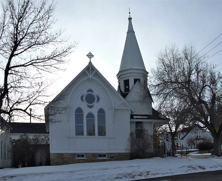
Photo: Wikimedia, CC BY-SA 3.0.
St. Paul's Episcopal Church in Evanston, Wyoming is a historic parish of the Episcopal Church in the Carpenter Gothic style. The church was built in 1884–1885, and at the time was the only Protestant church in a community dominated by Mormons and Catholics. St. Paul’s Episcopal Church is situated 4,100 feet north of Smith’s Liquor Store.
Evanston Main Post Office
Building
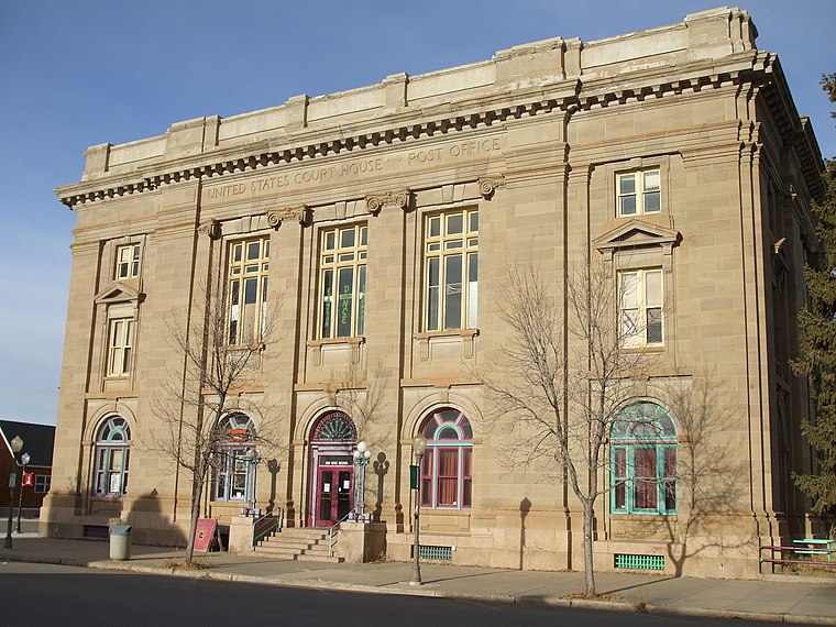
Photo: Tricia Simpson, CC BY-SA 3.0.
The Evanston Main Post Office in Evanston, Wyoming was built in 1905 as part of a facilities improvement program by the United States Post Office Department. Evanston Main Post Office is situated 1 mile north of Smith’s Liquor Store.
A. V. Quinn House
Building

Photo: Ntsimp, Public domain.
The A.V. Quinn House, also known as Pine Gables, was built in Evanston, Wyoming in 1883. The Victorian style house is a largely unaltered representative of the Queen Anne style in Evanston. A. V. Quinn House is situated 1 mile north of Smith’s Liquor Store.
Places in the Area
Nearby places include Evanston and Almy.
Evanston

Photo: Milonica, CC BY-SA 3.0.
Evanston is a city in Southwest Wyoming. The town was founded during the construction of the first transcontinental railroad and maintains a strong railroad history. The population was 11,700 people in 2020.
Almy
Hamlet
Almy was a coal mining camp in Uinta County, Wyoming, United States, near the town of Evanston. In 1881, an explosion killed 38 miners in the Central Pacific Mine, marking the first mine explosion west of the Mississippi River. Almy is situated 6 miles north of Smith’s Liquor Store.
Smith’s Liquor Store
- Type: Liquor store
- Categories: building and shop
- Location: Uinta, Wyoming, Rocky Mountains, United States, North America
- View on OpenStreetMap
Latitude
41.25487° or 41° 15′ 18″ northLongitude
-110.96921° or 110° 58′ 9″ westOpen location code
85HF723J+W8OpenStreetMap ID
way 1014891331OpenStreetMap feature
building=yesOpenStreetMap feature
shop=alcohol
This page is based on OpenStreetMap, Wikidata, and Wikimedia Commons.
We’d love your help improving our open data sources. Thank you for contributing.
Satellite Map
Discover Smith’s Liquor Store from above in high-definition satellite imagery.
Notable Places Nearby
Highlights include Flex Fitness and Trinity Lutheran Church.
Nearby Places
Explore places such as Pizza Hut and Cowboy Cares Home Health.
Wyoming: Must-Visit Destinations
Delve into Cheyenne, Casper, Laramie, and Gillette.
Curious Liquor Stores to Discover
Uncover intriguing liquor stores from every corner of the globe.
About Mapcarta. Data © OpenStreetMap contributors and available under the Open Database License". Text is available under the CC BY-SA 4.0 license, except for photos, directions, and the map. Photo: Lumpytrout, CC BY-SA 3.0.