Pstrągi
Pstrągi is in Gmina Radków, Kłodzko County, Lower Silesian Voivodeship. Pstrągi is situated nearby to the miniature golf course Adventure Mini Golf, as well as near the scenic viewpoint Ochota Magdaleńska.| Tap on a place to explore it |
Places of Interest Nearby
Highlights include Szczeliniec Wielki and Pośny waterfall.
Szczeliniec Wielki
Scenic viewpoint
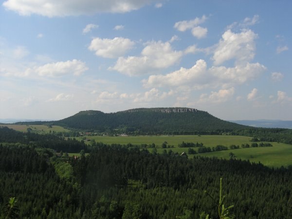
Photo: Drozdp, Public domain.
Szczeliniec Wielki is the highest peak of the Table Mountains in the Table Mountains National Park in Lower Silesia, Poland. It is very close to the Poland-Czech border, but entirely within Polish territory. Szczeliniec Wielki is situated 3 km west of Pstrągi.
Pośny waterfall
Waterfall

Photo: Poconaco, CC BY-SA 3.0 pl.
Pośny waterfall is situated 1½ km west of Pstrągi.

Places in the Area
Nearby places include Leśna and Radkowskie Skały.


Radków
Town

Photo: Jacek Halicki, CC BY-SA 4.0.
Radków is a town in Kłodzko County, Lower Silesian Voivodeship, in south-western Poland. It is the seat of the administrative district called Gmina Radków, close to the Czech border. As at 2019, the town has a population of 2,406.
Pstrągi
Latitude
50.49185° or 50° 29′ 31″ northLongitude
16.38174° or 16° 22′ 54″ eastOpen location code
9F2RF9RJ+PMOpenStreetMap ID
way 1015118120OpenStreetMap feature
natural=waterOpenStreetMap feature
water=oczko
This page is based on OpenStreetMap, Wikidata, and Wikimedia Commons.
We’d love your help improving our open data sources. Thank you for contributing.
Satellite Map
Discover Pstrągi from above in high-definition satellite imagery.
Places with the Same Name
Discover other places named “Pstrągi”.
Notable Places Nearby
Highlights include Adventure Mini Golf and Ochota Magdaleńska.
Nearby Places
Explore places such as Świątynia Dumania and Centrum Łąkowa 1.
Lower Silesian Voivodeship: Must-Visit Destinations
Delve into Wrocław, Legnica, Wałbrzych, and Głogów.
Curious Places to Discover
Uncover intriguing places from every corner of the globe.
About Mapcarta. Data © OpenStreetMap contributors and available under the Open Database License". Text is available under the CC BY-SA 4.0 license, except for photos, directions, and the map. Photo: Sicherlich, CC BY 3.0.