Recycling-Park Goslar
Recycling-Park Goslar is in Goslar, Southern Lower Saxony, Lower Saxony, and is located on Grauhöfer Landwehr. Recycling-Park Goslar is situated nearby to Lange Wiese, as well as near the forest Magdeburgskamp.| Tap on a place to explore it |
- Opening hours:
March—November: Monday—Friday 6:30 AM—5:00 PM; Saturday 7:00 AM—noon
December—February: Monday—Friday 7:00 AM—4:00 PM
public holidays: closed - Type: Industry
- Address: Grauhöfer Landwehr 10, Goslar, 38644
Places of Interest Nearby
Highlights include Stiftskirche St. Georg and St. Benno.
Stiftskirche St. Georg
Church

Photo: Rabanus Flavus, CC0.
Stiftskirche St. Georg is a church, which is situated 1½ km east of Recycling-Park Goslar.
St. Benno
Church

Photo: Kirchenfan, CC0.
St. Benno is a church, which is situated 1½ km southeast of Recycling-Park Goslar.
Goslar station
Railway station
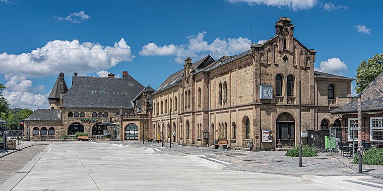 Goslar is a railway station located in Goslar, Germany. The station opened on 23 March 1866 and is located on the Vienenburg–Goslar railway, Hildesheim–Goslar railway and Neuekrug-Hahausen–Goslar railway. Goslar station is situated 3 km south of Recycling-Park Goslar.
Places in the Area
Nearby places include Fliegerhorst and Baßgeige.


Recycling-Park Goslar
Latitude
51.94016° or 51° 56′ 25″ northLongitude
10.42305° or 10° 25′ 23″ eastOperator
Recycling-Park Harz GmbHOpen location code
9F3GWCRF+36OpenStreetMap ID
way 103549074OpenStreetMap feature
amenity=recyclingOpenStreetMap feature
landuse=industrial
This page is based on OpenStreetMap, Wikidata, and Wikimedia Commons.
We’d love your help improving our open data sources. Thank you for contributing.
Satellite Map
Discover Recycling-Park Goslar from above in high-definition satellite imagery.
Notable Places Nearby
Highlights include Lange Wiese and Magdeburgskamp.
Nearby Places
Explore places such as Elektro-Könker GmbH and Med-X-Press.
Southern Lower Saxony: Must-Visit Destinations
Delve into Göttingen, Hamelin, Hann. Münden, and Einbeck.
Curious Places to Discover
Uncover intriguing places from every corner of the globe.
About Mapcarta. Data © OpenStreetMap contributors and available under the Open Database License". Text is available under the CC BY-SA 4.0 license, except for photos, directions, and the map. Photo: Wikimedia, CC0.