Axis Offices
Axis Offices is a building in Berlin, Berlin. Axis Offices is situated nearby to the railway station Berlin Ostkreuz (Ringbahn-F), as well as near Berlin Ostkreuz (Stadtbahn-F).| Tap on a place to explore it |
Places of Interest Nearby
Highlights include Berlin Ostkreuz station and Berlin-Rummelsburg railway station.
Berlin Ostkreuz station
Railway station
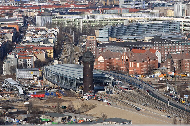
Photo: Wo st 01, CC BY-SA 3.0 de.
Berlin Ostkreuz station is a station on the Berlin S-Bahn suburban railway and the busiest interchange station in Berlin. It is in the former East Berlin district of Friedrichshain, now part of the borough of Friedrichshain-Kreuzberg. Berlin Ostkreuz station is situated 160 metres northwest of Axis Offices.
Berlin-Rummelsburg railway station
Railway station

Photo: Andre de, CC BY-SA 3.0.
Berlin-Rummelsburg station is a station in the suburb of Rummelsburg in the Lichtenberg district of Berlin. The station is located on the Berlin–Frankfurt railway and is served by line S3 of the Berlin S-Bahn. Berlin-Rummelsburg railway station is situated 520 metres east of Axis Offices.
Soviet War Memorial

Photo: Wikimedia, CC BY-SA 3.0.
The Soviet War Memorial is a war memorial and military cemetery in Berlin's Treptower Park. It was built to the design of the Soviet architect Yakov Belopolsky to commemorate 7,000 of the 80,000 Red Army soldiers who fell in the Battle of Berlin in April–May 1945. Soviet War Memorial is situated 1½ km south of Axis Offices.
Places in the Area
Nearby places include Stralau and Rudolfkiez.


Axis Offices
- Type: Commercial building
- Roof shape: flat
- Categories: building and office
- Location: Berlin, Berlin, Stadt, Berlin, Germany, Central Europe, Europe
- View on OpenStreetMap
Latitude
52.50183° or 52° 30′ 7″ northLongitude
13.47068° or 13° 28′ 15″ eastLevels
9Operator
SGI Immobilien Entwicklung und Verwaltung GmbHOpen location code
9F4MGF2C+P7OpenStreetMap ID
way 1051870200OpenStreetMap feature
building=commercialOpenStreetMap attribute
roof-shape=flat
This page is based on OpenStreetMap, Wikidata, and Wikimedia Commons.
We’d love your help improving our open data sources. Thank you for contributing.
Satellite Map
Discover Axis Offices from above in high-definition satellite imagery.
Notable Places Nearby
Highlights include Berlin Ostkreuz (Ringbahn-F) and Berlin Ostkreuz (Stadtbahn-F).
Nearby Places
Explore places such as neXenio GmbH and msg systems AG.
Berlin: Must-Visit Destinations
Delve into Mitte, East Central, City West, and East Berlin.
Curious Places to Discover
Uncover intriguing places from every corner of the globe.
About Mapcarta. Data © OpenStreetMap contributors and available under the Open Database License". Text is available under the CC BY-SA 4.0 license, except for photos, directions, and the map. Photo: Berthold Werner, CC BY-SA 3.0.