Piermont station
Piermont Railroad Station is a historic train station located at Piermont in Rockland County, New York. It was built about 1873 by the Northern Railroad of New Jersey, later acquired by the Erie Railroad.| Tap on a place to explore it |
Photo: RussNelson, CC BY-SA 3.0.
- Type: Building
- Description: railway station in Piermont, the United States of America
- Also known as: “Piermont”
- Address: 50 Ash Street, Piermont, NY 10968
Places of Interest Nearby
Highlights include Christ Church and Rockland Country Club.
Christ Church
Church

Photo: KLOTZPLATE, CC BY-SA 4.0.
Christ Church, also known as Christ Episcopal Church, is a historic Episcopal church located at Sparkill in Rockland County, New York. It was designed by architect Charles Babcock and built in 1864–1865. Christ Church is situated 1 mile southwest of Piermont station.
Rockland Country Club
Golf course
Rockland Country Club is located in Sparkill, New York, and features an 18-hole golf course. Rockland Country Club is situated 1¼ miles south of Piermont station.
Ardsley-on-Hudson station
Railway station
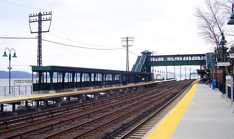
Photo: Daniel Case, CC BY-SA 3.0.
Ardsley-on-Hudson station is a commuter rail stop on the Metro-North Railroad's Hudson Line, located in the Ardsley Park area of Irvington, New York. It serves both the neighborhood and the northern part of the village of Dobbs Ferry; the main campus of Mercy College is within walking distance of the station. Ardsley-on-Hudson station is situated 2½ miles southeast of Piermont station.
Places in the Area
Nearby places include Piermont and Sparkill.
Piermont

Photo: Jim.henderson, Public domain.
Piermont is a village incorporated in 1847 in Rockland County, New York, United States. Piermont is in the town of Orangetown, located north of the hamlet of Palisades, east of Sparkill, and south of Grand View-on-Hudson, on the west bank of the Hudson River.
Sparkill
Village

Photo: Taurus876, Public domain.
Sparkill, formerly known as Tappan Sloat, is a suburban hamlet and census-designated place in the Town of Orangetown, Rockland County, New York, United States located north of Palisades; east of Tappan; south of Piermont and west of the Hudson River.
Grand View-on-Hudson
Hamlet
Grand View-on-Hudson is a village incorporated in 1918 in the town of Orangetown in Rockland County, New York, United States. It is located north of Piermont, east of Orangeburg, south of South Nyack, and west of the Hudson River. Grand View-on-Hudson is situated 1½ miles north of Piermont station.
Piermont station
- Categories: railway station and historic site
- Location: Orangetown, Rockland County, Downstate New York, New York, Mid-Atlantic, United States, North America
- View on OpenStreetMap
Latitude
41.04154° or 41° 2′ 30″ northLongitude
-73.91838° or 73° 55′ 6″ westOpen location code
87H823RJ+JJOpenStreetMap ID
way 105426881OpenStreetMap feature
building=yesOpenStreetMap feature
historic=station_siteWikidata ID
Q7191905
This page is based on OpenStreetMap, Wikidata, Wikimedia Commons, and Wikipedia.
We’d love your help improving our open data sources. Thank you for contributing.
Satellite Map
Discover Piermont station from above in high-definition satellite imagery.
Notable Places Nearby
Highlights include Empire Host Co # 1 and Dennis P. Mchugh Piermont Public Library.
Nearby Places
Explore places such as Turning Point Restaurant and TWK Market Place.
Rockland County: Must-Visit Destinations
Delve into Nyack, Spring Valley, New City, and Suffern.
Curious Buildings to Discover
Uncover intriguing buildings from every corner of the globe.
About Mapcarta. Data © OpenStreetMap contributors and available under the Open Database License". Text is available under the CC BY-SA 4.0 license, except for photos, directions, and the map. Description text is based on the Wikipedia page “Piermont station”. Photo: RussNelson, CC BY-SA 3.0.