Dünen
Dünen is in Norderney, Aurich, Lower Saxony. Dünen is situated nearby to the ruins Batterie Ost, as well as near the scenic viewpoint Postbake.| Tap on a place to explore it |
Places of Interest Nearby
Highlights include Norderney Airport and Leuchtturm Norderney.
Norderney Airport
Aerodrome
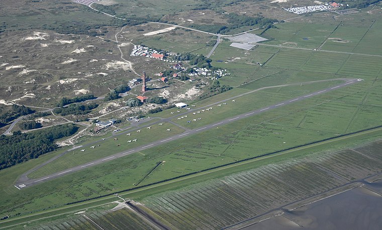
Photo: Carsten Steger, CC BY-SA 4.0.
Norderney Airport is an airport on the island of Norderney in Lower Saxony, Germany. Having been opened in 1970, the airport is an integral part of the island's infrastructure, serving as a faster way to get onto or off the island compared to shipping, and being available even when maritime traffic is suspended in the winter due to ice. Norderney Airport is situated 2½ km southwest of Dünen.
Leuchtturm Norderney
Building
 Leuchtturm Norderney is a building, which is situated 2½ km west of Dünen.
Places in the Area
Nearby places include Hilgenriedersiel and Nordhelm.
Hilgenriedersiel
Village

Photo: GregorHelms, CC BY-SA 3.0.
Hilgenriedersiel is a village in the region of East Frisia, Lower Saxony, Germany. It is an Ortsteil of the municipality of Hagermarsch, part of the municipal association of Hage. Hilgenriedersiel is situated 6 km south of Dünen.
Nordhelm
Suburb

Photo: Bin im Garten, CC BY-SA 3.0.
Nordhelm is a suburb, which is situated 7 km west of Dünen.
Napoleonschanze
Locality

Photo: Aeroid, CC BY-SA 3.0.
Napoleonschanze is a locality, which is situated 7 km west of Dünen.
Dünen
- Type: Sand
- Category: landform
- Location: Norderney, Aurich, Lower Saxony, Germany, Central Europe, Europe
- View on OpenStreetMap
Latitude
53.71772° or 53° 43′ 4″ northLongitude
7.26493° or 7° 15′ 54″ eastOpen location code
9F59P797+3XOpenStreetMap ID
way 1055220841OpenStreetMap feature
natural=sand
This page is based on OpenStreetMap, Wikidata, and Wikimedia Commons.
We’d love your help improving our open data sources. Thank you for contributing.
Satellite Map
Discover Dünen from above in high-definition satellite imagery.
Places with the Same Name
Discover other places named “Dünen”.
Notable Places Nearby
Highlights include Batterie Ost and Postbake.
Nearby Places
Explore places such as Ostheller and Campingplatz Harms.
Lower Saxony: Must-Visit Destinations
Delve into Hanover, Göttingen, Brunswick, and Wolfsburg.
Curious Places to Discover
Uncover intriguing places from every corner of the globe.
About Mapcarta. Data © OpenStreetMap contributors and available under the Open Database License". Text is available under the CC BY-SA 4.0 license, except for photos, directions, and the map. Photo: Danapit, CC BY-SA 3.0.