Christian IX’s Palæ
Christian IX’s Palæ is a building in Indre By, Copenhagen municipality, Capital Region. Christian IX’s Palæ is situated nearby to the building Kolonnaden, as well as near Amalienborg.| Tap on a place to explore it |
Photo: Bahnfrend, CC BY-SA 4.0.
- Type: Tourist attraction
- Description: building in Copenhagen Municipality, Denmark
- Also known as: “Christian den IX’s Palæ”
- Roof shape: hipped
Places of Interest Nearby
Highlights include Amalienborg and Frederik’s Church.
Amalienborg
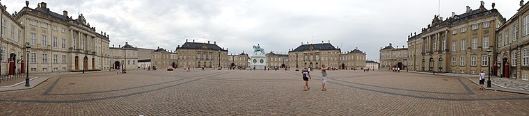
Photo: Janeway666, CC BY-SA 3.0.
Amalienborg is the official residence for the Danish royal family and is located in Copenhagen. Frederick VIII's palace complex has four identical Classical façades, effectively four palaces, with Rococo interiors, laid around an octagonal courtyard.
Frederik’s Church
Church

Photo: Jakubhal, CC BY-SA 4.0.
Frederik's Church, popularly known as The Marble Church for its rococo architecture, is an Evangelical Lutheran church in Copenhagen, Denmark. The church forms the focal point of the Frederiksstaden district; it is located due west of Amalienborg Palace. Frederik’s Church is situated 300 metres northwest of Christian IX’s Palæ.
Amaliehaven
Park

Photo: Martin Nikolaj Christensen, CC BY 2.0.
Amaliehaven is a small park located between Amalienborg Palace and the waterfront in the Frederiksstaden neighbourhood of central Copenhagen, Denmark. It was established in 1983 as a gift from the A.P.
Places in the Area
Nearby places include Frederiksstaden and Nyboder.
Frederiksstaden
Quarter

Photo: Manscher, CC BY-SA 3.0.
Frederiksstaden is a district in Copenhagen, Denmark. Constructed during the reign of Frederick V in the second half of the 18th century, it is considered to be one of the most important rococo complexes in Europe and was included in the 2006 Danish Culture Canon.
Nyboder
Quarter

Photo: Wikimedia, CC BY-SA 3.0.
Nyboder is a historic row house district of former Naval barracks in Copenhagen, Denmark. It was planned and first built by Christian IV to accommodate a need for housing for the personnel of the rapidly growing Royal Danish Navy and their families during that time.
Christiania
 Christiania is a self-governing "free town" established in 1971, a city within the city, on the site of a military barracks as an alternative to mainstream culture. Christiania is considered to be the fourth largest tourist attraction in Copenhagen.
Christian IX’s Palæ
- Categories: building and tourism
- Location: Indre By, Copenhagen municipality, Capital Region, Denmark, Nordic countries, Europe
- View on OpenStreetMap
Latitude
55.68345° or 55° 41′ 0″ northLongitude
12.59353° or 12° 35′ 37″ eastInception
1755Levels
3Named after
Christian IX of DenmarkOpen location code
9F7JMHMV+9COpenStreetMap ID
way 106105466OpenStreetMap feature
building=yesOpenStreetMap feature
tourism=attractionOpenStreetMap attribute
roof-shape=hippedWikidata ID
Q112821537
This page is based on OpenStreetMap, Wikidata, and Wikimedia Commons.
We’d love your help improving our open data sources. Thank you for contributing.
Satellite Map
Discover Christian IX’s Palæ from above in high-definition satellite imagery.
In Other Languages
“Christian IX’s Palæ” goes by many names.
- Danish: “Christian IX’s Palæ”
- Danish: “Schacks Palæ”
Notable Places Nearby
Highlights include Kolonnaden and Amalienborg Slotsplads.
Nearby Places
Explore places such as Tandlægernes Hus and Amalienborg.
Denmark: Must-Visit Destinations
Delve into Copenhagen, Aarhus, Odense, and Aalborg.
Curious Places to Discover
Uncover intriguing places from every corner of the globe.
About Mapcarta. Data © OpenStreetMap contributors and available under the Open Database License". Text is available under the CC BY-SA 4.0 license, except for photos, directions, and the map. Photo: Bahnfrend, CC BY-SA 4.0.