HUK-Parkhaus
HUK-Parkhaus is a parking area in Coburg, Upper Franconia, Bavaria. Access is restricted and requires permission. HUK-Parkhaus is situated nearby to the church Königreichssaal Zeugen Jehovas Coburg, as well as near the building Schloss Hohenfels.| Tap on a place to explore it |
- Access is restricted and requires permission.
- Type: Parking area
- Parking: multi-storey
Places of Interest Nearby
Highlights include Coburg and Heilig-Kreuz-Kirche.
Coburg
Railway station

Photo: Störfix, CC BY-SA 3.0.
Coburg is a railway station, which is situated 640 metres south of HUK-Parkhaus.
Heilig-Kreuz-Kirche
Church

Photo: Störfix, CC BY-SA 3.0.
Heilig-Kreuz-Kirche is a church, which is situated 600 metres southeast of HUK-Parkhaus.
Coburg Fortress
Castle
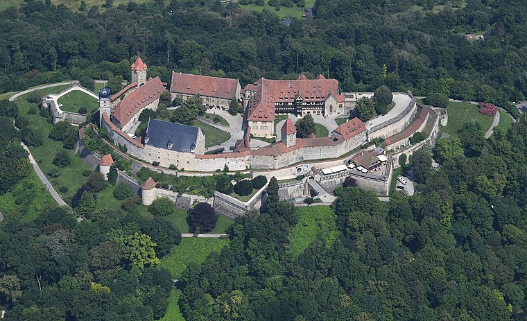
Photo: Carsten Steger, CC BY-SA 4.0.
The Veste Coburg is one of the best-preserved medieval fortresses of Germany. It is situated on a hill above the town of Coburg, in the Upper Franconia region of Bavaria. Coburg Fortress is situated 1½ km east of HUK-Parkhaus.
Places in the Area
Nearby places include Neuses and Bertelsdorf.


HUK-Parkhaus
- Categories: building and transportation
- Location: Coburg, Coburg, Upper Franconia, Franconia, Bavaria, Germany, Central Europe, Europe
- View on OpenStreetMap
Latitude
50.26845° or 50° 16′ 6″ northLongitude
10.95833° or 10° 57′ 30″ eastOperator
HUK CoburgOpen location code
9F2G7X95+98OpenStreetMap ID
way 1073886459OpenStreetMap feature
amenity=parkingOpenStreetMap feature
building=yesOpenStreetMap attribute
parking=multi-storey
This page is based on OpenStreetMap, Wikidata, and Wikimedia Commons.
We’d love your help improving our open data sources. Thank you for contributing.
Satellite Map
Discover HUK-Parkhaus from above in high-definition satellite imagery.
Notable Places Nearby
Highlights include Königreichssaal Zeugen Jehovas Coburg and Schloss Hohenfels.
Nearby Places
Explore places such as Edeka and Höreder Beck.
Upper Franconia: Must-Visit Destinations
Delve into Bamberg, Bayreuth, Hof, and Kulmbach.
Curious Parking Areas to Discover
Uncover intriguing parking areas from every corner of the globe.
About Mapcarta. Data © OpenStreetMap contributors and available under the Open Database License". Text is available under the CC BY-SA 4.0 license, except for photos, directions, and the map. Photo: Benreis, CC BY 3.0.